The Luzon Island Group is the largest administrative division of the Philippines, composed of 8 regions, 38 provinces, and hundreds of cities and municipalities. This guide explains Luzon’s administrative structure, regional divisions, provinces, and LGUs.
Luzon Island Group – Complete Administrative Guide
Luzon is the largest and most administratively complex island group in the Philippines. It contains the nation’s capital region, the Cordillera highlands, major agricultural basins, and the country’s most densely populated urban centers.
This page serves as the master administrative hub for all Luzon Regions, Provinces, Cities, and Municipalities.
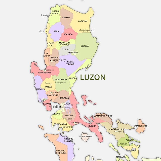
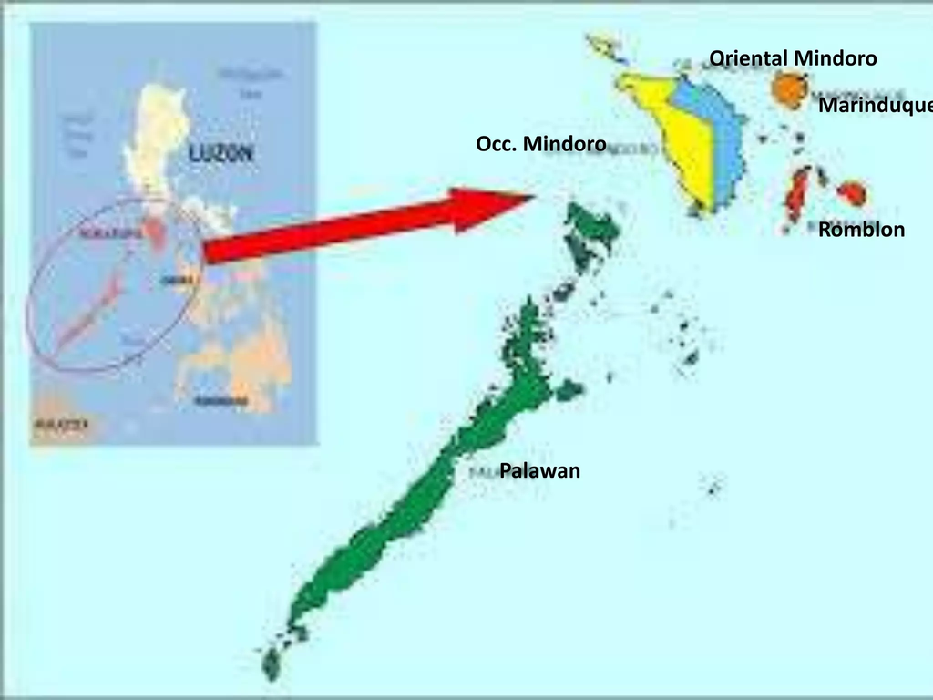
by pinnaxis.com by slideshare.net
Overview of the Luzon Island Group
Luzon covers the northern portion of the Philippines and includes:
- 8 Administrative Regions
- 38 Provinces
- 70+ Cities
- Hundreds of Municipalities
- Thousands of Barangays
Luzon is home to the country’s political capital (NCR), major economic corridors, and diverse cultural and ethnolinguistic groups.
Administrative Regions of Luzon
Below is the complete list of Luzon’s administrative regions, each linking to its own regional administrative page.
Luzon Regions
- Region I – Ilocos Region
- Region II – Cagayan Valley
- Region III – Central Luzon
- Region IV‑A – CALABARZON
- Region IV‑B – MIMAROPA
- Region V – Bicol Region
- NCR – National Capital Region
- CAR – Cordillera Administrative Region
Luzon contains 38 provinces, grouped by region. This section links each province to its administrative page.
Ilocos Region (Region I)
- Ilocos Norte
- Ilocos Sur
- La Union
- Pangasinan
Cagayan Valley (Region II)
- Batanes
- Cagayan
- Isabela
- Nueva Vizcaya
- Quirino
Central Luzon (Region III)
- Aurora
- Bataan
- Bulacan
- Nueva Ecija
- Pampanga
- Tarlac
- Zambales
CALABARZON (Region IV‑A)
- Cavite
- Laguna
- Batangas
- Rizal
- Quezon
MIMAROPA (Region IV‑B)
- Occidental Mindoro
- Oriental Mindoro
- Marinduque
- Romblon
- Palawan
Bicol Region (Region V)
- Albay
- Camarines Norte
- Camarines Sur
- Catanduanes
- Masbate
- Sorsogon
NCR – National Capital Region
- Metro Manila (16 Cities + 1 Municipality)
CAR – Cordillera Administrative Region
- Abra
- Apayao
- Benguet
- Ifugao
- Kalinga
- Mountain Province
Cities & Municipalities of Luzon
Province LGU Index Pages
- Cities & Municipalities of Ilocos Norte
- Cities & Municipalities of Ilocos Sur
- Cities & Municipalities of La Union
- Cities & Municipalities of Pangasinan
Major Cities and Urban Centers of the Luzon Island Group
Luzon contains many of the Philippines’ most important administrative, economic, educational, and transportation centers. These cities serve as regional capitals, trade hubs, tourism gateways, and major population centers that help drive the country’s development.
Notable Cities of Luzon
- Baguio City (CAR) – Known as the Summer Capital of the Philippines and the primary urban center of the Cordillera highlands.
- Angeles City (Central Luzon) – A major commercial and service center adjacent to Clark Freeport and Clark International Airport.
- Olongapo City (Central Luzon) – A strategic port and tourism city serving the Subic Bay area.
- Lucena City (CALABARZON) – An important gateway connecting Southern Luzon with the island provinces of Eastern Philippines.
- Naga City (Bicol Region) – A leading educational, religious, and commercial center of the Bicol Region.
- Tuguegarao City (Cagayan Valley) – The administrative and economic center of the Cagayan Valley Region.
- Dagupan City (Ilocos Region) – A major trade center known for fisheries, commerce, and regional services.
- Legazpi City (Bicol Region) – The primary gateway to Mayon Volcano and one of Southern Luzon’s leading tourism centers.
These cities collectively support government services, commerce, education, transportation, and tourism throughout the Luzon Island Group.
Geographic
Geography
Luzon contains diverse landscapes including:
- Mountain ranges (Cordillera, Sierra Madre)
- Coastal plains
- Volcanic zones
- Major river basins (Cagayan River, Pampanga River)
Key Geographic Features of the Luzon Island Group
The Luzon Island Group contains some of the Philippines’ most recognizable natural landmarks and geographic features, ranging from mountain ranges and volcanoes to major river systems and internationally recognized protected areas.
Cultural Groups
Luzon is home to:
- Ilocano
- Tagalog
- Kapampangan
- Bicolano
- Cordilleran ethnolinguistic groups
- Pangasinense
Major Natural Landmarks
- Mount Pulag – The highest mountain in Luzon and one of the country’s most popular hiking destinations.
- Cagayan River – The longest river system in the Philippines, flowing through much of Northern Luzon.
- Mayon Volcano – World-famous for its near-perfect cone shape and symbol of the Bicol Region.
- Taal Volcano – One of the world’s most unique volcano systems, located within Taal Lake in Batangas.
- Cordillera Mountain Range – Home to the Rice Terraces of the Philippine Cordilleras and many indigenous communities.
- Sierra Madre Mountain Range – The longest mountain range in the Philippines and a critical biodiversity corridor.
- Puerto Princesa Underground River – A UNESCO World Heritage Site and one of the country’s most significant natural attractions.
- Palawan Karst Landscapes – Limestone cliffs, lagoons, and island formations that rank among the Philippines’ most iconic landscapes.
These natural features contribute to Luzon’s ecological diversity, tourism industry, agricultural productivity, and cultural identity.
Economic & Infrastructure Profile
Key Economic Zones
- Metro Manila
- CALABARZON industrial belt
- Clark–Subic corridor
- Baguio–La Trinidad economic zone
Major Infrastructure
- NAIA
- Clark International Airport
- North Luzon Expressway (NLEX)
- South Luzon Expressway (SLEX)
- TPLEX
- PNR North & South rail corridors
Major Travel Destinations in the Luzon Island Group
While this guide focuses on administration and geography, the Luzon Island Group is also home to many of the Philippines’ most visited travel destinations.
While Luzon serves as the administrative and economic center of the Philippines, it is also home to many of the country’s most visited cultural, historical, and natural attractions. From UNESCO World Heritage Sites and active volcanoes to world-famous islands and mountain destinations, Luzon offers some of the most diverse travel experiences in the archipelago.
Popular Destinations
- Baguio City – Mountain scenery, cool climate, parks, and cultural attractions.
- Vigan City – UNESCO World Heritage Site known for Spanish colonial architecture.
- Palawan – Home to El Nido, Coron, Puerto Princesa, and some of the country’s most famous island destinations.
- Bicol Region – Known for Mayon Volcano, Caramoan, and adventure tourism.
- Ilocos Region – Famous for heritage sites, coastal scenery, windmills, and beaches.
- Quezon Province – Offers island destinations, mountain landscapes, and cultural heritage attractions.
- Mindoro – Popular for diving, beaches, and access to Apo Reef and Puerto Galera.
- Batanes – Remote island landscapes, traditional Ivatan culture, and dramatic coastal scenery.
Together, these destinations make Luzon the most geographically diverse and frequently visited island group in the Philippines, offering everything from mountain adventures and cultural heritage sites to world-class beaches and island-hopping experiences.
Related Guides
- Administrative Divisions
- Island Groups of the Philippines
- Visayas Island Group
- Mindanao Island Group
Conclusion
The Luzon Island Group is the administrative backbone of the Philippines, containing the nation’s capital, major economic corridors, and the largest concentration of provinces, cities, and municipalities. This page serves as your central hub for navigating Luzon’s complete administrative structure.