A comprehensive guide to the Philippines’ three major island groups—Luzon, Visayas, Mindanao. Covers geography, cultural distinctions, administrative relevance, and how regions and provinces fit into each group.
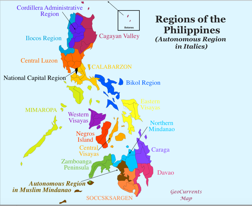
Map by animalia-life.club
Philippine Island Groups: Luzon, Visayas, Mindanao — Complete Geographic & Cultural Guide
The Philippines is divided into three major island groups—Luzon, Visayas, and Mindanao—a national structure used in geography, culture, administration, and statistical reporting. These island groups are not political units themselves, but they organize the country’s 7,641 islands, 17 regions, and 82 provinces into three large, recognizable clusters. Understanding these groups is essential for navigating Philippine geography, planning travel, studying culture, or building structured informational content.
Luzon Island Group
The Luzon Island Group is the largest and most populous of the three, home to the national capital, major economic centers, and diverse cultural landscapes. It includes the main island of Luzon plus several surrounding island provinces.
Geographic Boundaries of Luzon
Luzon occupies the northern third of the Philippines. Its boundaries stretch from the Batanes Islands near Taiwan down to Mindoro, Marinduque, and Palawan in the southwest.
Key geographic zones include:
- Northern Luzon — Cordillera mountains, Cagayan Valley plains
- Central Luzon — Pampanga River basin, agricultural heartland
- Southern Luzon — volcanic belts, lakes, and coastal peninsulas
- MIMAROPA — island provinces southwest of Luzon
Major islands in the Luzon group:
- Luzon
- Mindoro
- Marinduque
- Palawan
Cultural Distinctions of Luzon
Luzon’s cultural identity is shaped by:
- Cordilleran Indigenous Groups — Ifugao, Kankanaey, Bontoc
- Lowland Christian Communities — Tagalog, Kapampangan, Pangasinense
- Spanish Colonial Heritage — churches, plazas, ancestral towns
- Urban Cosmopolitan Culture — Manila’s global influence
Luzon is the Philippines’ center for:
- National government
- Finance and commerce
- Higher education
- Media and transportation
Administrative Relevance of Luzon
Luzon contains 8 administrative regions:
- Ilocos Region (Region I)
- Cagayan Valley (Region II)
- Cordillera Administrative Region (CAR)
- Central Luzon (Region III)
- CALABARZON (Region IV‑A)
- MIMAROPA (Region IV‑B)
- Bicol Region (Region V)
- National Capital Region (NCR)
These regions contain 38 provinces, each with distinct cultural and geographic identities.
How Provinces Fit Into the Luzon Group
Luzon’s provinces are grouped by geography and culture:
- Northern Highlands — Mountain Province, Benguet, Ifugao
- Northern Lowlands — Cagayan, Isabela, Nueva Vizcaya
- Central Plains — Pampanga, Tarlac, Bulacan, Nueva Ecija
- Southern Tagalog — Batangas, Laguna, Cavite, Quezon
- Island Provinces — Palawan, Mindoro, Marinduque
Each province contributes to Luzon’s role as the country’s political and economic core.
Visayas Island Group
The Visayas Island Group lies at the center of the Philippine archipelago. Known for its maritime culture, historic cities, and world‑class beaches, the Visayas is a cultural and geographic bridge between Luzon and Mindanao.
Geographic Boundaries of the Visayas
The Visayas consist of several mid‑sized islands, forming three sub‑clusters:
- Western Visayas — Panay, Guimaras, Negros Occidental
- Central Visayas — Cebu, Bohol, Siquijor, Negros Oriental
- Eastern Visayas — Leyte, Samar, Biliran
Major islands:
- Cebu
- Bohol
- Negros
- Panay
- Leyte
- Samar
Cultural Distinctions of the Visayas
The Visayas are known for:
- Visayan Languages — Cebuano, Hiligaynon, Waray
- Maritime Traditions — boat‑building, fishing, seafaring
- Historic Cities — Cebu City, Iloilo City, Tacloban
- Festivals — Sinulog, Dinagyang, Ati‑Atihan
The Visayan identity emphasizes:
- Hospitality
- Music and dance
- Strong coastal community ties
Administrative Relevance of the Visayas
The Visayas contain three administrative regions:
- Western Visayas (Region VI)
- Central Visayas (Region VII)
- Eastern Visayas (Region VIII)
These regions include 16 provinces, each contributing to the Visayas’ cultural and economic diversity.
How Provinces Fit into the Visayas Group
Provinces are grouped by island clusters:
- Western Visayas (Region VI) — Iloilo, Antique, Capiz, Aklan, Guimaras, Negros Occidental
- Central Visayas (Region VII)— Cebu, Bohol, Siquijor, Negros Oriental
- Eastern Visayas (Region VIII) — Northern Leyte, Western Samar, Eastern Samar, Northern Samar, Biliran
This structure reflects both geography and linguistic-cultural divisions.
Mindanao Island Group
The Mindanao Island Group covers the southern third of the Philippines. It is known for its cultural diversity, fertile agricultural lands, and growing eco‑tourism destinations.
Geographic Boundaries of Mindanao
Mindanao includes:
- The main island of Mindanao
- The Sulu Archipelago — Basilan, Sulu, Tawi‑Tawi
- Offshore islands and coastal provinces
Major geographic zones:
- Zamboanga Peninsula (Region IX)— coastal settlements and cultural fusion
- Northern Mindanao (Region X)— plateaus and coastal cities
- Davao Region (Region XI) — fertile valleys and volcanic landscapes
- SOCCSKSARGEN (Region XII) — agricultural plains
- BARMM (Region XV) — autonomous Muslim-majority provinces
H2: Cultural Distinctions of Mindanao
Mindanao’s cultural identity is shaped by:
- Indigenous Lumad Groups — Manobo, Bagobo, Subanen
- Muslim Communities — Tausug, Yakan, Maranao, Maguindanao
- Christian Settler Communities — Cebuano-speaking migrants
- Rich Islamic Heritage — mosques, royal houses, traditional arts
Mindanao is the Philippines’ center for:
- Muslim Filipino culture
- Agricultural production
- Emerging eco‑tourism
Administrative Relevance of Mindanao
Mindanao contains six administrative regions:
- Zamboanga Peninsula (Region IX)
- Northern Mindanao (Region X)
- Davao Region (Region XI)
- SOCCSKSARGEN (Region XII)
- Caraga (Region XIII)
- BARMM (Bangsamoro Autonomous Region) (Region XV)
These regions include 28 provinces, each with distinct cultural and geographic identities.
How Provinces Fit Into the Mindanao Group
Mindanao’s provinces are grouped by cultural and geographic zones:
- Northern Mindanao — Bukidnon, Misamis Oriental, Misamis Occidental
- Davao Region — Davao del Sur, Davao Oriental, Davao de Oro
- SOCCSKSARGEN — South Cotabato, Sultan Kudarat, Sarangani
- Zamboanga Peninsula — Zamboanga del Sur, Zamboanga del Norte
- BARMM — Lanao del Sur, Maguindanao del Norte, Sulu, Tawi‑Tawi
This structure reflects Mindanao’s complex cultural mosaic.
Conclusion — Why the Island Groups Matter
The division of the Philippines into Luzon, Visayas, and Mindanao provides a clear framework for understanding:
- Geographic organization of thousands of islands
- Cultural diversity across regions
- Administrative structure used for governance and statistics
- Regional identity that shapes travel, history, and national development
For travelers, researchers, and content creators, mastering the island group structure is essential for producing accurate, organized, and SEO‑ready Philippine information.
Related Philippine Guides
- Philippine Regions Explained
- Complete List of Philippine Provinces
- Island Geography of the Philippines
- Travel Guides by Region