Region II, or the Cagayan Valley Region, consists of Batanes, Cagayan, Isabela, Nueva Vizcaya, and Quirino. This administrative guide covers its provinces, cities, municipalities, geography, economy, and LGU structure.
Region II – Cagayan Valley Administrative Guide
Region II, officially known as the Cagayan Valley Region, occupies the northeastern portion of Luzon. It is composed of five provinces—Batanes, Cagayan, Isabela, Nueva Vizcaya, and Quirino—and is known for its vast river systems, fertile plains, and rugged mountain ranges.
This page serves as the central administrative hub for all LGUs within Region II.
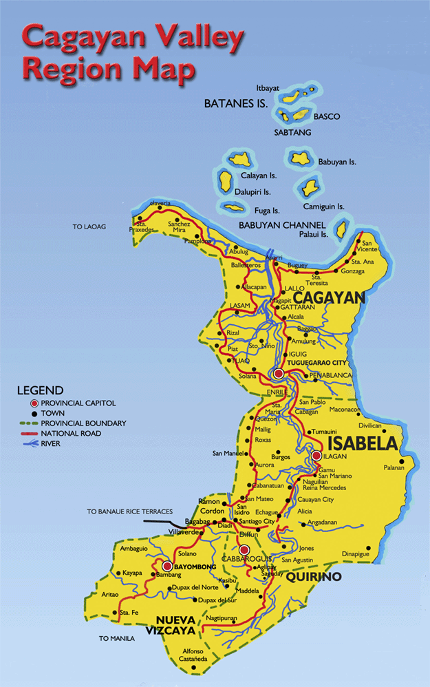
by prielsantillan.blogspot.com
Region Overview
- Island Group: Luzon
- Regional Center: Tuguegarao City
- Provinces: 5
- Cities: 4
- Municipalities: 89
- Barangays: 2,300+
- PSGC Code: 02000000
Region II is defined by the Cagayan River Basin, the largest river basin in the Philippines, and the Sierra Madre and Cordillera mountain ranges.
Provinces of Region II
Batanes
- Capital: Basco
- Batanes Administrative Page
- Cities & Municipalities of Batanes
Cagayan
- Capital: Tuguegarao City
- Cagayan Administrative Page
- Cities & Municipalities of Cagayan
Isabela
- Capital: Ilagan City
- Isabela Administrative Page
- Cities & Municipalities of Isabela
Nueva Vizcaya
- Capital: Bayombong
- Nueva Vizcaya Administrative Page
- Cities & Municipalities of Nueva Vizcaya
Quirino
- Capital: Cabarroguis
- Quirino Administrative Page
- Cities & Municipalities of Quirino
Cities of Region II
Component & Independent Cities
- Tuguegarao City – Regional Center
- Ilagan City – Provincial Capital of Isabela
- Cauayan City – Commercial Hub
- Santiago City – Independent Component City
Municipalities of Region II
Region II contains 89 municipalities, organized by province. Each province’s LGU index page provides complete listings:
- Batanes LGUs
- Cagayan LGUs
- Isabela LGUs
- Nueva Vizcaya LGUs
- Quirino LGUs
Geography & Environment
Landscape
Region II features:
- The Cagayan River, the longest river in the Philippines
- The Sierra Madre mountain range
- The Cordillera foothills
- Fertile agricultural plains
- Coastal zones (Cagayan, Batanes)
Climate
- Tropical monsoon
- Dry season: November–April
- Wet season: May–October
- Typhoon corridor (especially Cagayan & Isabela)
Cultural & Historical Profile
Region II is home to:
- Ibanag
- Itawes
- Ilocano
- Gaddang
- Yogad
- Ivatan (Batanes)
Cultural highlights include:
- Ivatan stone houses
- Cagayan churches
- Isabela heritage towns
- Indigenous Cordilleran communities in Nueva Vizcaya
Economic Profile
Key Sectors
- Agriculture (corn, rice, bananas, tobacco)
- Fisheries
- Livestock
- Trade & services
- Tourism (Batanes, Callao Cave, Sierra Madre eco‑tourism)
Major Infrastructure
- Tuguegarao Airport
- Cauayan Airport
- National highways connecting Cagayan Valley to Central Luzon
- Magat Dam (Isabela)
Internal Links
- Luzon Island Group
- Administrative Divisions
- Provinces of the Philippines
- Cities of the Philippines
- Municipalities of the Philippines
Conclusion
Region II – Cagayan Valley is one of Luzon’s most geographically diverse and agriculturally productive regions. This administrative page provides a complete overview of its provinces, cities, municipalities, and LGU structure, forming a key part of your national administrative silo