Region XIV: CAR Region:
Cordillera Administration Region:
Cordillera Administrative Region (CAR): A Glimpse into the Philippines’ Highland Treasure
The Cordillera Administrative Region (CAR), designated as region XIV is a landlocked region and is one of the 17 administrative regions of the Philippines. Located in the north-central portion of the island of Luzon, it is known for its mountainous terrain, rich indigenous culture, and cool climate. The region was created in 1987 under Executive Order No. 220, and it is the only landlocked region in the country.
Provinces and Capital
CAR is composed of six provinces and one highly urbanized city:
- Abra
- Apayao
- Benguet
- Ifugao
- Kalinga
- Mountain Province
- Baguio City – the regional center and a highly urbanized city known as the “Summer Capital of the Philippines.”
Geography and Climate
The Cordillera region is characterized by rugged mountains, deep valleys, and high plateaus. It includes the Cordillera Central mountain range, the largest in the Philippines. Due to its elevation, the region enjoys a cooler climate compared to much of the country, making it a popular destination for both local and foreign tourists.
People and Culture
CAR is home to numerous indigenous groups collectively referred to as the Igorots. These include the Bontoc, Kankanaey, Ibaloi, Ifugao, Kalinga, and Tingguian, among others. Each group has its own language, traditions, dances, rituals, and traditional attire.
One of the most iconic cultural landmarks of the region is the Banaue Rice Terraces, often called the “Eighth Wonder of the World.” These terraces, carved into the mountains by the Ifugao over 2,000 years ago, showcase the region’s ancient and sustainable farming practices.
Economy
The economy of CAR is primarily based on agriculture, mining, and tourism. The region produces highland crops such as vegetables, coffee, and temperate fruits. It is also rich in mineral resources like gold and copper. In recent years, eco-tourism and cultural tourism have grown significantly, with travelers drawn to the region’s natural beauty and heritage.
Challenges and Development
Despite its cultural richness and natural beauty, CAR faces challenges such as limited infrastructure, disaster vulnerability (e.g., landslides and earthquakes), and socio-political issues, especially around ancestral land rights. However, local and national governments, along with non-governmental organizations, continue to work toward sustainable development and indigenous peoples’ empowerment.
Interesting Facts
- The Cordillera region celebrates the “Cordillera Day” every July 15, commemorating the establishment of the region.
- Traditional weaving, wood carving, and tattooing are still practiced by many indigenous groups in the area.
- The Panagbenga Festival, held every February in Baguio City, is one of the most colorful and famous festivals in the country, celebrating flowers and local culture.
The Cordillera Administrative Region stands as a testament to the Philippines’ rich cultural heritage and natural beauty. It offers a unique experience that blends ancient traditions with breathtaking landscapes, making it a true gem of the north.
| PSGC # Base: | PSGC # | Region # | Region Name: | Province or HUC: | Primary Island: | Founded: | Capitol: | Income Class: | Pop. (2020): | Area (sq. km.): | Area (sq. mi.): | Ind. Cities: | Comp. Cities: | Municipalities: | Brys: | # Of Island Brys: |
|---|---|---|---|---|---|---|---|---|---|---|---|---|---|---|---|---|
| 14 | 140100000 | 14 | CAR- Cordillera Administrative Region | Abra | Luzon | 3/10/1917 | Bangued | 3rd | 250,985 | 4,165.25 | 1,608.21 | 0 | 0 | 27 | 303 | 0 |
| 14 | 148100000 | 14 | CAR- Cordillera Administrative Region | Apayao | Luzon | 2/14/1995 | Kabugao | 3rd | 124,366 | 4,413.35 | 1,704.00 | 0 | 0 | 7 | 133 | 0 |
| 14 | 141100000 | 14 | CAR- Cordillera Administrative Region | Benguet | Luzon | 6/16/1966 | La Trinidad | 2nd | 460,683 | 2,769.08 | 1,069.15 | 1 | 0 | 13 | 140 | 0 |
| 14 | 142700000 | 14 | CAR- Cordillera Administrative Region | Ifugao | Luzon | 6/18/1966 | Lagawe | 3rd | 207,498 | 2,628.21 | 1,014.76 | 0 | 0 | 11 | 175 | 0 |
| 14 | 143200000 | 14 | CAR- Cordillera Administrative Region | Kalinga | Luzon | 2/14/1995 | Tabuk City | 3rd | 229,570 | 3,231.25 | 1,247.59 | 0 | 1 | 7 | 152 | 0 |
| 14 | 144400000 | 14 | CAR- Cordillera Administrative Region | Mountain Province | Luzon | 1908 | Bontoc | 4th | 158,200 | 2,157.38 | 832.97 | 0 | 0 | 10 | 144 | 0 |
| 14 | 141102000 | 14 | CAR- Cordillera Administrative Region | Baguio City, Benguet | Luzon | 12/22/1979 | N/A | 1st | 366,358 | 57.51 | 22.20 | N/A | N/A | N/A | 129 | 0 |
| Pop.(2020): | Area (sq. km.): | Area (sq. mi.): | Ind. Cities: | Comp. Cities: | Municipalities: | Brys: | # Of Island Brys: | |||||||||
| Totals: | 1,797,660 | 19,422.03 | 7,498.88 | 1 | 1 | 75 | 1,176 | 0 |
Map of Region XIV: CAR-Cordillera Administration Region:
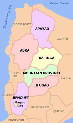
By Scorpion prinz at English Wikipedia, CC BY 2.5, https://commons.wikimedia.org/w/index.php?curid=5871812
Provinces of Region XIV: CAR-Cordillera Administration Region:
Abra:
Philippine Standard Geographical Code # 140100000
Abra, is a landlocked province, and is composed of:
| Municipality: | Barangay: |
|---|---|
| 27 | 304 |
| PSGC # | Town # | Creation Date: | Municipality: | Type: | Location: | Pop. (2020): | Pop. (2015): | Area (sq. km.): | Area (sq. mi.): | IDD: Area Code: | Zip Code: | Barangays | Income Class: | District: |
|---|---|---|---|---|---|---|---|---|---|---|---|---|---|---|
| 140101000 | 1 | 1598 | Bangued (Capitol) | Municipality | Landlocked | 50,382 | 43,936 | 105.70 | 40.81 | 63 (0) 74 | 2800 | 31 | 1st Class | Lone District |
| 140102000 | 2 | 1918 | Boliney | Municipality | Landlocked | 4,551 | 4,063 | 216.92 | 83.75 | 63 (0) 74 | 2815 | 8 | 5th Class | Lone District |
| 140103000 | 3 | 10/29/1846 | Bucay | Municipality | Landlocked | 17,953 | 17,126 | 107.17 | 41.38 | 63 (0) 74 | 2805 | 21 | 5th Class | Lone District |
| 140104000 | 4 | 1920 | Bucloc | Municipality | Landlocked | 2,395 | 2,176 | 63.77 | 24.62 | 63 (0) 74 | 2817 | 4 | 5th Class | Lone District |
| 140105000 | 5 | Daguioman | Municipality | Landlocked | 2,019 | 1,715 | 114.37 | 44.16 | 63 (0) 74 | 2816 | 4 | 6th Class | Lone District | |
| 140106000 | 6 | 1921 | Danglas | Municipality | Landlocked | 4,074 | 4,734 | 156.02 | 60.24 | 63 (0) 74 | 2825 | 7 | 5th Class | Lone District |
| 140107000 | 7 | 1882 | Dolores | Municipality | Landlocked | 11,512 | 11,499 | 47.45 | 18.32 | 63 (0) 74 | 2801 | 15 | 5th Class | Lone District |
| 140108000 | 8 | 1832 | La Paz | Municipality | Landlocked | 16,493 | 14,882 | 51.41 | 19.85 | 63 (0) 74 | 2826 | 12 | 5th Class | Lone District |
| 140109000 | 9 | 1948 | Lacub | Municipality | Landlocked | 3,612 | 2,977 | 295.30 | 114.02 | 63 (0) 74 | 2821 | 6 | 5th Class | Lone District |
| 140110000 | 10 | 1918 | Lagangilang | Municipality | Landlocked | 14,914 | 13,824 | 101.44 | 39.17 | 63 (0) 74 | 2802 | 17 | 5th Class | Lone District |
| 140111000 | 11 | 1926 | Lagayan | Municipality | Landlocked | 4,488 | 4,477 | 215.97 | 83.39 | 63 (0) 74 | 2824 | 6 | 6th Class | Lone District |
| 140112000 | 12 | Langiden | Municipality | Landlocked | 3,576 | 3,170 | 116.29 | 44.90 | 63 (0) 74 | 2807 | 6 | 5th Class | Lone District | |
| 140113000 | 13 | 1960 | Licuan-Baay (Licuan) | Municipality | Landlocked | 4,566 | 4,864 | 256.42 | 99.00 | 63 (0) 74 | 2819 | 11 | 5th Class | Lone District |
| 140114000 | 14 | 1912 | Luba | Municipality | Landlocked | 6,518 | 6,391 | 148.27 | 57.25 | 63 (0) 74 | 2813 | 8 | 5th Class | Lone District |
| 140115000 | 15 | 9/1/1960 | Malibcong | Municipality | Landlocked | 4,027 | 3,807 | 283.17 | 109.33 | 63 (0) 74 | 2820 | 12 | 5th Class | Lone District |
| 140116000 | 16 | Manabo | Municipality | Landlocked | 11,611 | 10,756 | 110.95 | 42.84 | 63 (0) 74 | 2810 | 11 | 5th Class | Lone District | |
| 140117000 | 17 | 3/5/1917 | Peñarrubia | Municipality | Landlocked | 6,951 | 6,544 | 38.29 | 14.78 | 63 (0) 74 | 2804 | 9 | 5th Class | Lone District |
| 140118000 | 18 | Pidigan | Municipality | Landlocked | 12,475 | 11,528 | 49.15 | 18.98 | 63 (0) 74 | 2806 | 15 | 5th Class | Lone District | |
| 140119000 | 19 | 1903 | Pilar | Municipality | Landlocked | 10,146 | 9,908 | 66.10 | 25.52 | 63 (0) 74 | 2812 | 19 | 5th Class | Lone District |
| 140120000 | 20 | Sallapadan | Municipality | Landlocked | 6,389 | 5,985 | 128.62 | 49.66 | 63 (0) 74 | 2818 | 9 | 5th Class | Lone District | |
| 140121000 | 21 | 4/10/1950 | San Isidro | Municipality | Landlocked | 4,745 | 4,888 | 48.07 | 18.56 | 63 (0) 74 | 2809 | 9 | 6th Class | Lone District |
| 140122000 | 22 | 2/28/1929 | San Juan | Municipality | Landlocked | 10,688 | 10,546 | 64.08 | 24.74 | 63 (0) 74 | 2823 | 19 | 5th Class | Lone District |
| 140123000 | 23 | 1887 | San Quintin | Municipality | Landlocked | 5,705 | 5,233 | 66.59 | 25.71 | 63 (0) 74 | 2808 | 6 | 5th Class | Lone District |
| 140124000 | 24 | 1725 | Tayum | Municipality | Landlocked | 14,869 | 13,940 | 61.14 | 23.61 | 63 (0) 74 | 2803 | 11 | 5th Class | Lone District |
| 140125000 | 25 | Tineg | Municipality | Landlocked | 4,977 | 4,668 | 744.80 | 287.57 | 63 (0) 74 | 2822 | 10 | 4th Class | Lone District | |
| 140126000 | 26 | Tubo | Municipality | Landlocked | 5,674 | 5,719 | 409.87 | 158.25 | 63 (0) 74 | 2814 | 10 | 3rd Class | Lone District | |
| 140127000 | 27 | 1903 | Villaviciosa | Municipality | Landlocked | 5,675 | 5,377 | 102.93 | 39.74 | 63 (0) 74 | 2811 | 8 | 5th Class | Lone District |
| Pop. (2020): | Pop. (2015): | Area (sq. km.): | Area (sq. mi.): | Bry: | ||||||||||
| Totals: | 250,985 | 234,733 | 4,170.26 | 1,610.15 | 304 |
Apayao:
Philippine Standard Geographical Code # 148100000
Apayao, is a landlocked province, and is composed of:
| Municipality: | Barangay: |
|---|---|
| 7 | 133 |
| PSGC # | Town # | Creation Date: | Municipality: | Type: | Location: | Pop.(2020): | Pop. (2015): | Area (sq. km.): | Area (sq. mi.): | IDD: Area Code: | Zip Code: | Barangays: | Income Class: | District: |
|---|---|---|---|---|---|---|---|---|---|---|---|---|---|---|
| 148101000 | 1 | 6/25/1963 | Calanasan (Bayag) | Municipality | Landlocked | 12,550 | 11,568 | 1,256.15 | 485.00 | 63 (0) 74 | 3814 | 18 | 1st Class | Lone District |
| 148102000 | 2 | 6/25/1963 | Conner | Municipality | Landlocked | 27,552 | 24,811 | 694.30 | 268.07 | 63 (0) 74 | 3807 | 21 | 3rd Class | Lone District |
| 148103000 | 3 | 6/22/1963 | Flora | Municipality | Landlocked | 17,944 | 16,743 | 324.40 | 125.25 | 63 (0) 74 | 3810 | 16 | 4th Class | Lone District |
| 148104000 | 4 | 6/25/1963 | Kabugao (Capitol) | Municipality | Landlocked | 16,215 | 16,170 | 935.12 | 361.05 | 63 (0) 74 | 3809 | 21 | 2nd Class | Lone District |
| 148105000 | 5 | 9/6/1929 | Luna | Municipality | Landlocked | 21,297 | 18,029 | 606.04 | 233.99 | 63 (0) 74 | 3813 | 22 | 3rd Class | Lone District |
| 148106000 | 6 | 12/3/1929 | Pudtol | Municipality | Landlocked | 15,491 | 13,305 | 401.02 | 154.83 | 63 (0) 74 | 3812 | 22 | 4th Class | Lone District |
| 148107000 | 7 | 6/17/1967 | Santa Marcela | Municipality | Landlocked | 13,317 | 12,010 | 196.32 | 75.80 | 63 (0) 74 | 3811 | 13 | 5th Class | Lone District |
| Pop. (2020): | Pop. (2015): | Area (sq. km.): | Area (sq. mi.): | Barangays: | ||||||||||
| Totals: | 124,366 | 112,636 | 4,413.35 | 1,703.99 | 133 |
Benguet:
Philippine Standard Geographical Code # 141100000
Benguet, is a landlocked province and is made is composed of:
| Independent City | Municipality: | Barangay: |
|---|---|---|
| Baguio City | 13 | 3269 |
| PSGC # | Town # | Creation Date: | Municipality: | Type: | Location: | Pop. (2020): | Area (sq. km.): | Area (sq. mi.): | IDD: Area Code: | Zip Code: | Barangays: | Income Class: | District: |
|---|---|---|---|---|---|---|---|---|---|---|---|---|---|
| 141101000 | 1 | 8/13/1908 | Atok | Municipality | Landlocked | 19,218 | 214.99 | 83.01 | 63 (0) 74 | 2612 | 8 | 4th Class | Lone District |
| 141102000 | 2 | 1900 | Baguio City | Independent City | Landlocked | 366,358 | 57.51 | 22.20 | 63 (0) 74 | 2600 | 129 | 1st Class | Lone District of Baguio City |
| 141103000 | 3 | 8/13/1908 | Bakun | Municipality | Landlocked | 14,535 | 286.91 | 110.78 | 63 (0) 74 | 2610 | 7 | 3rd Class | Lone District |
| 141104000 | 4 | 6/25/1963 | Bokod | Municipality | Landlocked | 14,435 | 274.96 | 106.16 | 63 (0) 74 | 2605 | 10 | 1st Class | Lone District |
| 141105000 | 5 | 2/29/1942 | Buguias | Municipality | Landlocked | 44,877 | 175.88 | 67.91 | 63 (0) 74 | 2607 | 14 | 3rd Class | Lone District |
| 141106000 | 6 | 2/5/1951 | Itogon | Municipality | Landlocked | 61,498 | 449.73 | 173.64 | 63 (0) 74 | 2604 | 9 | 1st Class | Lone District |
| 141107000 | 7 | 6/18/1966 | Kabayan | Municipality | Landlocked | 15,806 | 242.69 | 93.70 | 63 (0) 74 | 2606 | 13 | 4th Class | Lone District |
| 141108000 | 8 | 6/18/1966 | Kapangan | Municipality | Landlocked | 19,297 | 164.39 | 63.47 | 63 (0) 74 | 2613 | 15 | 4th Class | Lone District |
| 141109000 | 9 | unknown | Kibungan | Municipality | Landlocked | 17,051 | 254.86 | 98.40 | 63 (0) 74 | 2611 | 7 | 4th Class | Lone District |
| 141110000 | 10 | 6/16/1950 | La Trinidad (Capitol) | Municipality | Landlocked | 137,404 | 70.04 | 27.04 | 63 (0) 74 | 2601 | 16 | 1st Class | Lone District |
| 141111000 | 11 | 6/16/1955 | Mankayan | Municipality | Landlocked | 37,233 | 130.48 | 50.38 | 63 (0) 74 | 2608 | 12 | 1st Class | Lone District |
| 141112000 | 12 | 7/1/1927 | Sablan | Municipality | Landlocked | 11,588 | 105.63 | 40.78 | 63 (0) 74 | 2614 | 8 | 5th Class | Lone District |
| 141113000 | 13 | 12/11/1911 | Tuba | Municipality | Landlocked | 48,312 | 295.97 | 114.27 | 63 (0) 74 | 2603 | 13 | 1st Class | Lone District |
| 141114000 | 14 | 11/1/1900 | Tublay | Municipality | Landlocked | 19,429 | 102.55 | 39.59 | 63 (0) 74 | 2615 | 8 | 5th Class | Lone District |
| Pop. (2020): | Area (sq. km.): | Area (sq. mi.): | Barangays: | ||||||||||
| Totals: | 827,041 | 2,827 | 1,091 | 269 |
Ifugao:
Philippine Standard Geographical Code # 142700000
Ifugao, is a landlocked province and is made is composed of:
| Municipality: | Barangay: |
|---|---|
| 11 | 176 |
| PSGC # | Town # | Creation Date: | Municipality: | Type: | Location: | Pop. (2020): | Pop. (2015): | Area (sq. km.): | Area (sq. mi.): | IDD: Area Code: | Zip Code: | Barangays: | Income Class: | District: |
|---|---|---|---|---|---|---|---|---|---|---|---|---|---|---|
| 142708000 | 8 | 9/20/1980 | Aguinaldo | Municipality | Landlocked | 21,128 | 19,408 | 538.05 | 207.74 | 63 (0) 74 | 3606 | 16 | 2nd Class | Lone District |
| 142707000 | 7 | 1955 | Alfonso Lista | Municipality | Landlocked | 34,061 | 32,119 | 347.46 | 134.16 | 63 (0) 74 | 3608 | 20 | 3rd Class | Lone District |
| 142711000 | 11 | 1/13/1992 | Asipulo | Municipality | Landlocked | 15,963 | 15,261 | 182.87 | 70.61 | 63 (0) 74 | 3610 | 9 | 5th Class | Lone District |
| 142701000 | 1 | 6/25/1963 | Banaue | Municipality | Landlocked | 20,652 | 21,837 | 191.20 | 73.82 | 63 (0) 74 | 3601 | 18 | 4th Class | Lone District |
| 142709000 | 9 | 4/15/1983 | Hingyon | Municipality | Landlocked | 9,930 | 9,227 | 62.02 | 23.95 | 63 (0) 74 | 3607 | 12 | 5th Class | Lone District |
| 142702000 | 2 | 6/25/1963 | Hungduan | Municipality | Landlocked | 8,866 | 9,400 | 260.30 | 100.50 | 63 (0) 74 | 3603 | 9 | 5th Class | Lone District |
| 142703000 | 3 | 6/25/1963 | Kiangan | Municipality | Landlocked | 17,691 | 17,048 | 200.00 | 77.22 | 63 (0) 74 | 3604 | 15 | 4th Class | Lone District |
| 142704000 | 4 | 6/18/1963 | Lagawe (Capitol) | Municipality | Landlocked | 18,876 | 19,333 | 208.91 | 80.66 | 63 (0) 74 | 3600 | 20 | 4th Class | Lone District |
| 142705000 | 5 | 1959 | Lamut | Municipality | Landlocked | 26,235 | 25,279 | 159.65 | 61.64 | 63 (0) 74 | 3605 | 18 | 4th Class | Lone District |
| 142706000 | 6 | 6/25/1963 | Mayoyao | Municipality | Landlocked | 15,621 | 17,331 | 238.05 | 91.91 | 63 (0) 74 | 3602 | 27 | 4th Class | Lone District |
| 142710000 | 10 | 3/1/1983 | Tinoc | Municipality | Landlocked | 18,475 | 16,559 | 239.70 | 92.55 | 63 (0) 74 | 3609 | 12 | 5th Class | Lone District of Ifugao |
| Pop. (2020): | Pop. (2015): | Area (sq. km.): | Area (sq. mi.): | Barangays: | ||||||||||
| 207,498 | 202,802 | 2,628.21 | 1,014.76 | 176 |
Kalinga:
Philippine Standard Geographical Code # 143200000
Kalinga is a landlocked province and is composed of:
| Component City (1): | Municipality: | Barangay: |
|---|---|---|
| Tabuk City | 8 | 152 |
| PSGC # | Town # | Creation Date: | Municipality: | Type: | Location: | Pop. (2020): | Pop. (2015): | Area (sq. km.): | Area (sq. mi.): | IDD: Area Code: | Zip Code: | Barangays: | Income Class: | District: |
|---|---|---|---|---|---|---|---|---|---|---|---|---|---|---|
| 143201000 | 1 | 8//18/1908 | Balbalan | Municipality | Landlocked | 12,914 | 12,195 | 542.69 | 209.53 | 63 (0) 74 | 3801 | 14 | 3rd Class | Lone District |
| 143206000 | 2 | 8//18/1908 | Lubuagan | Municipality | Landlocked | 9,323 | 8,733 | 234.20 | 90.43 | 63 (0) 74 | 3802 | 9 | 4th Class | Lone District |
| 143208000 | 3 | 6/18/1966 | Pasil | Municipality | Landlocked | 10,577 | 9,644 | 189.00 | 72.97 | 63 (0) 74 | 3803 | 14 | 5th Class | Lone District |
| 143209000 | 4 | 8//18/1908 | Pinukpuk | Municipality | Landlocked | 34,275 | 32,026 | 743.56 | 287.09 | 63 (0) 74 | 3806 | 23 | 2nd Class | Lone District |
| 143211000 | 5 | 6/19/1965 | Rizal (Liwan) | Municipality | Landlocked | 19,554 | 17,038 | 231.00 | 89.19 | 63 (0) 74 | 3808 | 14 | 4th Class | Lone District |
| 143213000 | 6 | 8//18/1908 | Tabuk City (Capitol) | Component City | Landlocked | 121,033 | 110,642 | 700.25 | 270.37 | 63 (0) 74 | 3800 | 42 | 3rd Class | Lone District |
| 143214000 | 7 | 1932 | Tanudan | Municipality | Landlocked | 8,746 | 9,534 | 307.55 | 118.75 | 63 (0) 74 | 3805 | 16 | 4th Class | Lone District |
| 143215000 | 8 | 8//18/1908 | Tinglayan | Municipality | Landlocked | 13,148 | 12,868 | 283.00 | 109.27 | 63 (0) 74 | 3804 | 20 | 4th Class | Lone District |
| Pop. (2020): | Pop. (2015): | Area (sq. km.): | Area (sq. mi.): | Barangays: | ||||||||||
| 229,570 | 212,680 | 3,231.25 | 1,247.60 | 152 |
Mountain Province:
Philippine Standard Geographical Code # 144400000
The Mountain Province is a landlocked province and is composed of:
| Municipality: | Barangay: |
|---|---|
| 10 | 144 |
| PSGC # | Town # | Creation Date: | Municipality: | Type: | Location: | Pop.(2020): | Pop. (2015): | Area (sq. km.): | Area (sq. mi.): | IDD: Area Code: | Barangays: | Income Class (2007): | District: | |
|---|---|---|---|---|---|---|---|---|---|---|---|---|---|---|
| 144401000 | 1 | Barlig | Municipality | Landlocked | 4,796 | 4,819 | 228.64 | 88.28 | 63 (0) 74 | 2623 | 11 | 5th Class | Lone District | |
| 144402000 | 2 | 1911 | Bauko | Municipality | Landlocked | 32,021 | 31,065 | 153.00 | 59.07 | 63 (0) 74 | 2621 | 22 | 4th Class | Lone District |
| 144403000 | 3 | 6/23/1963 | Besao | Municipality | Landlocked | 6,873 | 7,040 | 173.62 | 67.04 | 63 (0) 74 | 2618 | 14 | 5th Class | Lone District |
| 144404000 | 4 | 1887 | Bontoc (Capitol) | Municipality | Landlocked | 24,104 | 24,643 | 396.10 | 152.94 | 63 (0) 74 | 2616 | 16 | 3rd Class | Lone District |
| 144405000 | 5 | Natonin | Municipality | Landlocked | 10,339 | 10,272 | 252.00 | 97.30 | 63 (0) 74 | 2624 | 11 | 4th Class | Lone District | |
| 144406000 | 6 | 6/1/1962 | Paracelis | Municipality | Landlocked | 31,168 | 28,121 | 570.16 | 220.14 | 63 (0) 74 | 2625 | 9 | 2nd Class | Lone District |
| 144407000 | 7 | 7/25/1963 | Sabangan | Municipality | Landlocked | 9,621 | 9,315 | 72.04 | 27.81 | 63 (0) 74 | 2622 | 15 | 5th Class | Lone District |
| 144408000 | 8 | 7/25/1963 | Sadanga | Municipality | Landlocked | 8,427 | 8,799 | 83.30 | 32.16 | 63 (0) 74 | 2617 | 8 | 5th Class | Lone District |
| 144409000 | 9 | 1830 | Sagada | Municipality | Landlocked | 11,510 | 11,127 | 83.32 | 32.17 | 63 (0) 74 | 2619 | 19 | 5th Class | Lone District |
| 144410000 | 10 | 1957 | Tadian | Municipality | Landlocked | 19,341 | 19,389 | 145.20 | 56.06 | 63 (0) 74 | 2620 | 19 | 4th Class | Lone District |
| Pop. (2020): | Pop. (2015): | Area (sq. km.): | Area (sq. mi.): | Barangays: | ||||||||||
| 158,200 | 154,590 | 2,157.38 | 832.97 | 144 |