Region X: Northern Mindanao Region:
An Overview
Introduction
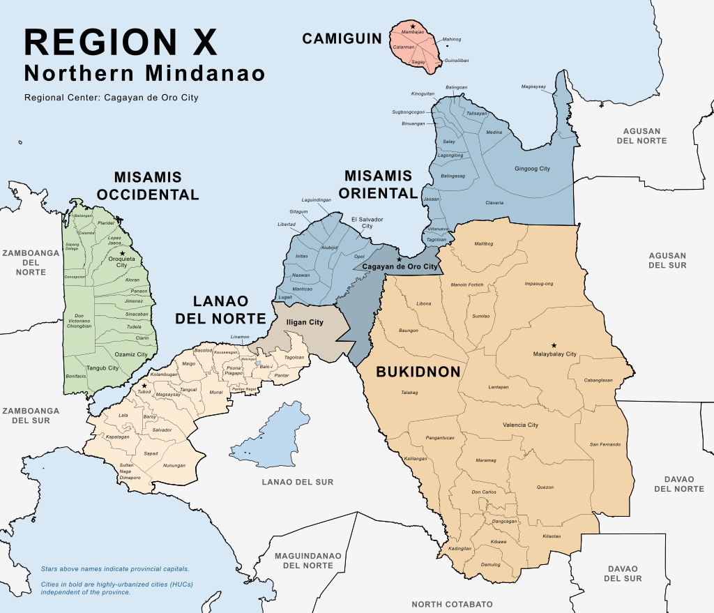
Northern Mindanao, officially known as Region X, is one of the 17 regions of the Philippines. Strategically located in the north-central part of Mindanao, this region serves as a gateway between the Visayas and the rest of Mindanao. It is known for its rich natural resources, diverse culture, and rapidly growing economy.
Geography and Provinces
Northern Mindanao is composed of five provinces:
- Bukidnon – A landlocked province known for its vast agricultural land and cool climate.
- Camiguin – An island province famous for its volcanoes, hot springs, and white sand beaches.
- Lanao del Norte – A coastal province with both agricultural and marine resources.
- Misamis Occidental – Known for its cultural heritage and historical landmarks.
- Misamis Oriental – Home to Cagayan de Oro, the region’s capital and economic hub.
The Region is bordered by Region IX: Zamboanga Peninsula to the west, Region XIII: the Caraga Administration Region to the north-east, Region XV: Bangsamoro Autonomous Region in Muslim Mindanao (BARMM) to the south-west, Region XII: SOCCSKSARGEN (Central Mindanao) to the south, Region XI: Davao (Southern Mindanao) to the south-east, and the Visayas Island Group to the north.
Capital and Major Cities
- Regional Center: Cagayan de Oro City
- Known as the “City of Golden Friendship,” it is a major center for trade, education, and tourism in Mindanao.
- Other key cities:
- Iligan City (Lanao del Norte)
- Valencia City and Malaybalay City (Bukidnon)
- Ozamiz City and Oroquieta City (Misamis Occidental)
- Gingoog City and El Salvador City (Misamis Oriental)
People and Culture
The region is home to a mix of indigenous peoples and settlers from various parts of the Philippines, resulting in a rich blend of cultures, languages, and traditions. Major languages spoken include Cebuano, Binukid, Higaonon, and Maranao, among others.
Cultural festivals such as the Kagay-an Festival (Cagayan de Oro), Kaamulan Festival (Bukidnon), and Lanzones Festival (Camiguin) showcase the region’s heritage and community spirit.
Economy
Northern Mindanao has a diverse and robust economy based on agriculture, trade, industry, and tourism.
- Agriculture: Major crops include rice, corn, pineapples (especially in Bukidnon), bananas, and coconut.
- Industry: The region has thriving industries such as food processing, metal craft, and energy production (notably hydropower from Iligan).
- Tourism: Attractions like Camiguin Island, Dahilayan Adventure Park, Tinago Falls, and Mapawa Nature Park draw both local and international tourists.
Natural Attractions
Northern Mindanao is rich in natural beauty, including:
- Mount Kitanglad Range Natural Park – A biodiversity hotspot in Bukidnon.
- Camiguin’s Volcanoes – Including Mt. Hibok-Hibok and the Sunken Cemetery.
- Maria Cristina Falls – A majestic waterfall that also serves as a hydroelectric power source.
- White Island and Mantigue Island – Popular beach destinations in Camiguin.
Conclusion
Northern Mindanao is a dynamic and vibrant region that plays a vital role in the socio-economic development of Mindanao and the Philippines as a whole. With its blend of natural wonders, cultural richness, and economic potential, it continues to attract investments, tourists, and people seeking opportunities.
| PSGC # Base | PSGC # | Region # | Region Name: | Province or HUC: | Capitol: | Income Class: | Pop. (2020): | Area (sq. km.): | Area (sq. mi.): | Ind. Cities: | Comp. Cities: | Municipalities: | Barangays: | # Island Brys: |
|---|---|---|---|---|---|---|---|---|---|---|---|---|---|---|
| 10 | 101300000 | 10 | Northern Mindanao | Bukidnon | Malaybalay City | 1st | 1,541,308 | 10,498.59 | 4,053.53 | 0 | 2 | 20 | 464 | 0 |
| 10 | 101800000 | 10 | Northern Mindanao | Camiguin | Mambajao | 5th | 92,808 | 237.95 | 91.87 | 0 | 0 | 5 | 58 | 58 |
| 10 | 103500000 | 10 | Northern Mindanao | Lanao del Norte | Tubod | 2nd | 722,902 | 3,346.57 | 1,292.12 | 1 | 0 | 22 | 462 | 0 |
| 10 | 104200000 | 10 | Northern Mindanao | Misamis Occidental | Oroquieta City | 2nd | 617,333 | 2,055.22 | 793.52 | 0 | 3 | 14 | 490 | 0 |
| 10 | 104300000 | 10 | Northern Mindanao | Misamis Oriental | Cagayan de Oro City | 1st | 956,900 | 3,131.52 | 1,209.09 | 1 | 2 | 23 | 424 | 0 |
| 10 | 104305000 | 10 | Northern Mindanao | Cagayan de Oro City, Misamis Oriental | N/A | 1st | 728,402 | 412.80 | 159.38 | N/A | N/A | N/A | 80 | 0 |
| 10 | 103504000 | 10 | Northern Mindanao | Iligan City, Lanao del Norte | N/A | 1st | 363,115 | 813.37 | 314.04 | N/A | N/A | N/A | 44 | 0 |
| Pop. (2020): | Area (sq. km.): | Area (sq. mi.): | Ind. Cities: | Comp. Cities: | Municipalities: | Barangays: | # Island Brys: | |||||||
| Totals: | 5,022,768 | 20,496.02 | 7,913.55 | 2 | 7 | 84 | 2,022 | 58 |
Map of Region X: Northern Mindanao Region:
By The original file from which this work is derived was created by User:Chlod. This derivative work is solely created by Benjiemar G. Dagala. – Derivative of .Philippines – Subnational Adminstrative Boundaries, courtesy of the United Nations Office for the Coordination of Humanitarian Affairs Human Development Exchange. Data sourced from the National Mapping and Resource Information Authority and Philippine Statistics Authority.Boundaries of Cagayan de Oro City from the Unified Land Information System of the City Planning and Development Office, City Government of Cagayan de Oro., Public Domain, https://commons.wikimedia.org/w/index.php?curid=132084903
Provinces of Region X: Northern Mindanao Region:
Bukidnon:
Philippine Standard Geographical Code # 101300000
Bukidnon, is a landlocked province, is composed of:
| Component City (1): | Municipalities: | Barangay: |
|---|---|---|
| Malaybalay City (Capitol) | 20 | 464 |
| Valencia City | N/A | N/A |
| PSGC # | Town # | Creation Date: | Municipality: | Type: | Landlocked: | Pop.(2020): | Pop. (2015): | Area (sq. km.): | Area (sq. mi.): | IDD: Area Code: | Zip Code: | Barangays: | Income Class: | District: |
|---|---|---|---|---|---|---|---|---|---|---|---|---|---|---|
| 101301000 | 1 | 7/1/1956 | Baungon | Municipality | Landlocked | 37,111 | 34,336 | 328.34 | 126.77 | 63 (0) 88 | 8707 | 16 | 2nd Class | I |
| 101322000 | 22 | 8/13/1979 | Cabanglasan | Municipality | Landlocked | 36,286 | 33,997 | 243.30 | 93.94 | 63 (0) 88 | 8723 | 15 | 3rd Class | II |
| 101302000 | 2 | 8/16/1971 | Damulog | Municipality | Landlocked | 39,322 | 30,302 | 244.19 | 94.28 | 63 (0) 88 | 8721 | 17 | 4th Class | III |
| 101303000 | 3 | 8/29/1961 | Dangcagan | Municipality | Landlocked | 26,076 | 23,723 | 422.69 | 163.20 | 63 (0) 88 | 8719 | 14 | 3rd Class | III |
| 101304000 | 4 | 6/18/1966 | Don Carlos | Municipality | Landlocked | 69,273 | 66,959 | 213.72 | 82.52 | 63 (0) 88 | 8712 | 29 | 1st Class | III |
| 101305000 | 5 | 9/1/1914 | Impasug-ong | Municipality | Landlocked | 53,863 | 47,859 | 1,051.17 | 405.86 | 63 (0) 88 | 8702 | 13 | 1st Class | II |
| 101306000 | 6 | 8/16/1971 | Kadingilan | Municipality | Landlocked | 33,735 | 33,778 | 171.94 | 66.39 | 63 (0) 88 | 8713 | 17 | 3rd Class | III |
| 101307000 | 7 | 6/18/1966 | Kalilangan | Municipality | Landlocked | 43,711 | 41,601 | 251.43 | 97.08 | 63 (0) 88 | 8718 | 14 | 2nd Class | IV |
| 101308000 | 8 | 7/1/1956 | Kibawe | Municipality | Landlocked | 41,897 | 39,612 | 304.13 | 117.43 | 63 (0) 88 | 8720 | 23 | 2nd Class | III |
| 101309000 | 9 | 6/18/1966 | Kitaotao | Municipality | Landlocked | 53,796 | 50,260 | 788.78 | 304.55 | 63 (0) 88 | 8716 | 35 | 1st Class | III |
| 101310000 | 10 | 6/18/1966 | Lantapan | Municipality | Landlocked | 65,974 | 61,776 | 328.35 | 126.78 | 63 (0) 88 | 8722 | 14 | 1st Class | II |
| 101311000 | 11 | 7/1/1956 | Libona | Municipality | Landlocked | 48,965 | 43,969 | 374.37 | 144.55 | 63 (0) 88 | 8706 | 14 | 1st Class | I |
| 101312000 | 12 | 10/19/1907 | Malaybalay City (Capitol) | Component City | Landlocked | 190,712 | 174,625 | 969.19 | 374.21 | 63 (0) 88 | 8700 | 46 | 1st Class | II |
| 101313000 | 13 | 6/25/1963 | Malitbog | Municipality | Landlocked | 26,741 | 174,625 | 969.19 | 374.21 | 63 (0) 88 | 8704 | 11 | 2nd Class | I |
| 101314000 | 14 | 6/21/1957 | Manolo Fortich | Municipality | Landlocked | 113,200 | 24,453 | 581.85 | 224.65 | 63 (0) 88 | 8703 | 22 | 1st Class | I |
| 101315000 | 15 | 7/1/1956 | Maramag | Municipality | Landlocked | 108,293 | 100,210 | 413.60 | 159.69 | 63 (0) 88 | 8714 | 20 | 1st Class | III |
| 101316000 | 16 | 6/25/1963 | Pangantucan | Municipality | Landlocked | 56,580 | 102,089 | 447.26 | 172.69 | 63 (0) 88 | 8717 | 19 | 1st Class | IV |
| 101317000 | 17 | 6/18/1966 | Quezon | Municipality | Landlocked | 109,624 | 53,126 | 461.72 | 178.27 | 63 (0) 88 | 8715 | 31 | 1st Class | III |
| 101318000 | 18 | 6/18/1966 | San Fernando | Municipality | Landlocked | 63,045 | 104,116 | 626.86 | 242.03 | 63 (0) 88 | 8711 | 24 | 1st Class | II |
| 101319000 | 19 | 7/1/1956 | Sumilao | Municipality | Landlocked | 29,531 | 27,660 | 196.95 | 76.04 | 63 (0) 88 | 8701 | 10 | 4th Class | I |
| 101320000 | 20 | 2/22/1917 | Talakag | Municipality | Landlocked | 77,027 | 71,644 | 786.40 | 303.63 | 63 (0) 88 | 8708 | 29 | 1st Class | I |
| 101321000 | 21 | 1/16/1961 | Valencia City | Component City | Landlocked | 216,546 | 192,993 | 587.29 | 226.75 | 63 (0) 88 | 8709 | 31 | 2nd Class | IV |
| Pop. (2020): | Pop. (2015): | Area (sq. km.): | Area (sq. mi.): | Barangays: | ||||||||||
| Totals: | 1,541,308 | 1,533,713.00 | 10,762.72 | 4,156 | 464 |
Camiguin:
Philippine Standard Geographical Code # 101800000
Camiguin, is an island province, is composed of:
| Municipalities: | Barangay (of which are Island Barangays): |
|---|---|
| 5 | 58 (58) |
| PSGC # | Town # | Creation Date: | Municipality: | Type: | Island: | Coastal: | Pop. (2020): | Pop. (2015): | Area (sq. km.): | Area (sq. mi.): | IDD: Area Code: | Zip Code: | Barangays: | Island Bry: | Income Class: | District: |
|---|---|---|---|---|---|---|---|---|---|---|---|---|---|---|---|---|
| 101801000 | 1 | Catarman | Municipality | Camiguin Island | Coastal | 17,569 | 16,798 | 53.75 | 20.75 | 63 (0) 88 | 9104 | 14 | 14 | 5th Class | Lone District | |
| 101802000 | 2 | 6/13/1950 | Guinsiliban | Municipality | Camiguin Island | Coastal | 6,685 | 6,281 | 18.52 | 7.15 | 63 (0) 88 | 9102 | 7 | 7 | 6th Class | Lone District |
| 101803000 | 3 | 9/14/1869 | Mahinog | Municipality | Camiguin Island | Coastal | 14,634 | 14,038 | 32.55 | 12.57 | 63 (0) 88 | 9101 | 13 | 13 | 5th Class | Lone District |
| 101804000 | 4 | 7/6/1855 | Mambajao (Capitol) | Municipality | Camiguin Island | Coastal | 41,094 | 38,735 | 89.00 | 34.36 | 63 (0) 88 | 9100 | 15 | 15 | 3rd Class | Lone District |
| 101805000 | 5 | 7/31/1899 | Sagay | Municipality | Camiguin Island | Coastal | 12,826 | 12,626 | 44.13 | 17.04 | 63 (0) 88 | 9103 | 9 | 9 | 5th Class | Lone District |
| Pop. (2020): | Pop. (2015): | Area (sq. km.): | Area (sq. mi.): | Barangays: | Island Bry: | |||||||||||
| Totals: | 92,808 | 88,478 | 237.95 | 91.87 | 58 | 58 |
Lanao del Norte:
Philippine Standard Geographical Code # 103500000
Lanao del Norte, is a coastal province, is composed of:
| Independent City (1): | Municipalities: | Barangay: |
|---|---|---|
| Iligan City | 22 | 506 |
| PSGC # | Town # | Creation Date: | Municipality: | Type: | Coastal/Inland: | Pop. (2020): | Pop. (2015): | Area (sq. km.): | Area (sq. mi.): | IDD: Area Code: | Zip Code: | Barangays: | Income Class: | District: |
|---|---|---|---|---|---|---|---|---|---|---|---|---|---|---|
| 103501000 | 1 | 5/10/1956 | Bacolod | Municipality | Coastal | 24,367 | 23,034 | 104.10 | 40.19 | 63 (0) 63 | 9205 | 16 | 4th Class | I |
| 103502000 | 2 | 8/1/1948 | Balo-i | Municipality | Inland | 68,465 | 58,383 | 90.98 | 35.13 | 63 (0) 63 | 9217 | 21 | 3rd Class | I |
| 103503000 | 3 | 6/10/1949 | Baroy | Municipality | Coastal | 24,683 | 22,600 | 72.35 | 27.93 | 63 (0) 63 | 9210 | 23 | 4th Class | I |
| 103504000 | 4 | 1609 | Iligan City | Independent City | Coastal | 363,115 | 342,618 | 813.37 | 314.04 | 63 (0) 63 | 9200 | 44 | 2nd Class | Lone District of Iligan City |
| 103505000 | 5 | 7/5/1949 | Kapatagan | Municipality | Coastal | 62,571 | 62,853 | 242.89 | 93.78 | 63 (0) 63 | 9214 | 33 | 2nd Class | II |
| 103507000 | 7 | 8/1/1948 | Kauswagan | Municipality | Coastal | 24,193 | 26,278 | 60.37 | 23.31 | 63 (0) 63 | 9202 | 13 | 5th Class | I |
| 103508000 | 8 | 7/1/1936 | Kolambugan | Municipality | Coastal | 28,265 | 27,005 | 134.55 | 51.95 | 63 (0) 63 | 9207 | 26 | 4th Class | I |
| 103509000 | 9 | 3/22/1949 | Lala | Municipality | Coastal | 73,425 | 67,727 | 140.25 | 54.15 | 63 (0) 63 | 9211 | 27 | 1st Class | II |
| 103510000 | 10 | 1/13/1960 | Linamon | Municipality | Coastal | 21,269 | 20,341 | 76.38 | 29.49 | 63 (0) 63 | 9201 | 8 | 5th Class | I |
| 103511000 | 11 | 12/10/1964 | Magsaysay | Municipality | Inland | 20,463 | 19,019 | 151.83 | 58.62 | 63 (0) 63 | 9221 | 24 | 5th Class | II |
| 103512000 | 12 | 2/27/1959 | Maigo | Municipality | Coastal | 23,337 | 21,666 | 121.45 | 46.89 | 63 (0) 63 | 9206 | 13 | 4th Class | I |
| 103513000 | 13 | 6/20/1949 | Matungao | Municipality | Inland | 14,756 | 13,975 | 45.74 | 17.66 | 63 (0) 63 | 9203 | 12 | 5th Class | I |
| 103514000 | 14 | 8/17/1917 | Munai | Municipality | Inland | 35,020 | 32,973 | 197.50 | 76.26 | 63 (0) 63 | 9219 | 26 | 4th Class | II |
| 103515000 | 15 | 7/1/1968 | Nunungan | Municipality | Inland | 18,827 | 18,367 | 473.28 | 182.73 | 63 (0) 63 | 9216 | 25 | 3rd Class | II |
| 103516000 | 16 | 6/1/1966 | Pantao Ragat | Municipality | Inland | 30,247 | 27,866 | 124.30 | 47.99 | 63 (0) 63 | 9208 | 20 | 4th Class | II |
| 103523000 | 23 | 6/11/1978 | Pantar | Municipality | Inland | 26,599 | 21,773 | 70.40 | 27.18 | 63 (0) 63 | 9218 | 21 | 5th Class | I |
| 103517000 | 17 | 3/31/1976 | Poona Piagapo | Municipality | Inland | 29,183 | 27,018 | 260.07 | 100.41 | 63 (0) 63 | 9204 | 26 | 4th Class | II |
| 103518000 | 18 | 1/13/1960 | Salvador | Municipality | Inland | 32,115 | 31,845 | 113.99 | 44.01 | 63 (0) 63 | 9212 | 25 | 5th Class | II |
| 103519000 | 19 | 6/21/1969 | Sapad | Municipality | Inland | 22,974 | 21,309 | 140.03 | 54.07 | 63 (0) 63 | 9213 | 17 | 5th Class | II |
| 103506000 | 6 | 4/10/1953 | Sultan Naga Dimaporo (Karomatan) | Municipality | Coastal | 60,904 | 56,764 | 230.99 | 89.19 | 63 (0) 63 | 9215 | 37 | 5th Class | II |
| 103520000 | 20 | 6/21/1969 | Tagoloan | Municipality | Inland | 15,091 | 13,253 | 69.70 | 26.91 | 63 (0) 63 | 9222 | 7 | 5th Class | I |
| 103521000 | 21 | 6/16/1956 | Tangcal | Municipality | Inland | 16,075 | 15,181 | 178.62 | 68.97 | 63 (0) 63 | 9220 | 18 | 5th Class | II |
| 103522000 | 22 | 10/17/1946 | Tubod (Capitol) | Municipality | Coastal | 50,073 | 47,165 | 246.80 | 95.29 | 63 (0) 63 | 9209 | 24 | 2nd Class | I |
| Pop. (2020): | Pop. (2015): | Area (sq. km.): | Area (sq. mi.): | Barangays: | ||||||||||
| Totals: | 1,086,017 | 1,019,013 | 4,159.94 | 1,606.15 | 506 |
Misamis Occidental:
Philippine Standard Geographical Code # 104200000
Misamis Occidental, is a coastal province, is composed of:
| Component City (2): | Municipalities: | Barangay: |
|---|---|---|
| Oroquieta City (Capitol) | 15 | 490 |
| Tangub City | N/A | N/A |
| PSGC # | Town # | Creation Date: | Municipality: | Type: | Coastal/Inland: | Pop. (2020): | Pop. (2015): | Area (sq. km.): | Area (sq. mi.): | IDD: Area Code: | Zip Code: | Barangays: | Income Class: | District: |
|---|---|---|---|---|---|---|---|---|---|---|---|---|---|---|
| 104201000 | 1 | 1/1/1917 | Aloran | Municipality | Coastal | 27,934 | 27,625 | 118.06 | 45.58 | 63 (0) 88 | 7206 | 38 | 4th Class | I |
| 104202000 | 2 | 8/10/1909 | Baliangao | Municipality | Coastal | 18,433 | 17,092 | 81.72 | 31.55 | 63 (0) 88 | 7211 | 15 | 5th Class | I |
| 104203000 | 3 | 1/2/1940 | Bonifacio | Municipality | Inland | 34,558 | 32,345 | 155.02 | 59.85 | 63 (0) 88 | 7215 | 28 | 4th Class | II |
| 104204000 | 4 | 2/14/1948 | Calamba | Municipality | Inland | 23,227 | 21,676 | 104.64 | 40.40 | 63 (0) 88 | 7210 | 19 | 4th Class | I |
| 104205000 | 5 | 2/21/1921 | Clarin | Municipality | Coastal | 39,356 | 37,548 | 84.50 | 32.63 | 63 (0) 88 | 7201 | 29 | 4th Class | II |
| 104206000 | 6 | 9/21/1956 | Concepcion | Municipality | Inland | 9,324 | 10,937 | 61.60 | 23.78 | 63 (0) 88 | 7213 | 18 | 6th Class | I |
| 104217000 | 17 | 2/8/1982 | Don Victoriano Chiongbian (Don M. Marcos) | Municipality | Inland | 9,664 | 10,183 | 284.60 | 109.88 | 63 (0) 88 | 7200 | 11 | 4th Class | II |
| 104207000 | 7 | 4/7/1900 | Jimenez | Municipality | Coastal | 28,909 | 27,654 | 81.43 | 31.44 | 63 (0) 88 | 7204 | 24 | 3rd Class | I |
| 104208000 | 8 | 8/1/1929 | Lopez Jaena | Municipality | Coastal | 25,507 | 25,055 | 94.70 | 36.56 | 63 (0) 88 | 7208 | 28 | 4th Class | I |
| 104209000 | 9 | 1/6/1936 | Oroquieta City (Capitol) | Component City | Coastal | 72,301 | 70,757 | 237.88 | 91.85 | 63 (0) 88 | 7207 | 47 | 4th Class | I |
| 104210000 | 10 | 7/16/1948 | Ozamiz City | Component City | Coastal | 140,334 | 141,828 | 169.95 | 65.62 | 63 (0) 88 | 7200 | 51 | 3rd Class | II |
| 104211000 | 11 | 6/18/1966 | Panaon | Municipality | Coastal | 10,797 | 10,209 | 46.80 | 18.07 | 63 (0) 88 | 7205 | 16 | 5th Class | I |
| 104212000 | 12 | 1907 | Plaridel | Municipality | Coastal | 39,840 | 38,900 | 80.00 | 30.89 | 63 (0) 88 | 7209 | 33 | 3rd Class | I |
| 104213000 | 13 | 8/12/1957 | Sapang Dalaga | Municipality | Coastal | 20,490 | 19,983 | 93.93 | 36.27 | 63 (0) 88 | 7212 | 28 | 5th Class | I |
| 104214000 | 14 | 8/30/1949 | Sinacaban | Municipality | Coastal | 19,671 | 18,391 | 99.09 | 38.26 | 63 (0) 88 | 7203 | 17 | 5th Class | II |
| 104215000 | 15 | 1930 | Tangub City (Regidor) | Component City | Coastal | 68,389 | 63,011 | 162.78 | 62.85 | 63 (0) 88 | 7214 | 55 | 4th Class | II |
| 104216000 | 16 | 2/21/1921 | Tudela | Municipality | Coastal | 28,599 | 28,932 | 98.52 | 38.04 | 63 (0) 88 | 7202 | 33 | 4th Class | II |
| Pop. (2020): | Pop. (2015): | Area (sq. km.): | Area (sq. mi.): | Barangays: | ||||||||||
| Totals: | 617,333 | 602,126 | 2,055.22 | 793.52 | 490 |
Misamis Oriental:
Philippine Standard Geographical Code # 104300000
Misamis Oriental, is a coastal province, is composed of:
| Independent City (1): | Component City (2): | Municipalities: | Barangay: |
|---|---|---|---|
| Cagayan de Oro City (Capitol) | El Salvador City | 23 | 504 |
| N/A | Gingoog City | N/A | N/A |
| PSGC # | Town # | Creation Date: | Municipality: | Type: | Coastal/Inland: | Pop. (2020): | Pop. (2015): | Area (sq. km.): | Area (sq. mi.): | IDD: Area Code: | Zip Code: | Barangays: | Income Class: | District: |
|---|---|---|---|---|---|---|---|---|---|---|---|---|---|---|
| 104301000 | 1 | Alubijid | Municipality | Coastal | 32,163 | 29,724 | 85.56 | 33.03 | 63 (0) 88 | 9018 | 16 | 4th Class | II | |
| 104302000 | 2 | 1842 | Balingasag | Municipality | Coastal | 74,385 | 67,059 | 147.11 | 56.80 | 63 (0) 88 | 9005 | 30 | 2nd Class | I |
| 104303000 | 3 | 3/1/1952 | Balingoan | Municipality | Coastal | 11,020 | 11,051 | 57.80 | 22.32 | 63 (0) 88 | 9011 | 9 | 5th Class | I |
| 104304000 | 4 | 6/15/1968 | Binuangan | Municipality | Coastal | 7,441 | 7,515 | 30.43 | 11.75 | 63 (0) 88 | 9008 | 8 | 6th Class | I |
| 104305000 | 5 | 1871 | Cagayan de Oro City (Capitol) | Independent City | Coastal | 728,402 | 675,950 | 412.80 | 159.38 | 63 (0) 88 | 9000 | 80 | 1st Class | 2 Lone Districts |
| 104306000 | 6 | 7/22/1950 | Claveria | Municipality | Inland | 52,478 | 48,906 | 579.63 | 223.80 | 63 (0) 88 | 9004 | 24 | 1st Class | II |
| 104307000 | 7 | 6/15/1948 | El Salvador City | Component City | Coastal | 58,771 | 50,204 | 106.15 | 40.98 | 63 (0) 88 | 9017 | 15 | 6th Class | II |
| 104308000 | 8 | 1750 | Gingoog City | Component City | Coastal | 136,698 | 124,648 | 568.44 | 219.48 | 63 (0) 88 | 9014 | 79 | 2nd Class | I |
| 104309000 | 9 | 6/8/1961 | Gitagum | Municipality | Coastal | 17,920 | 16,373 | 43.40 | 16.76 | 63 (0) 88 | 9020 | 11 | 5th Class | II |
| 104310000 | 10 | Initao | Municipality | Coastal | 33,902 | 32,370 | 111.27 | 42.96 | 63 (0) 88 | 9022 | 16 | 3rd Class | II | |
| 104311000 | 11 | 9/1/1948 | Jasaan | Municipality | Coastal | 57,055 | 54,478 | 77.02 | 29.74 | 63 (0) 88 | 9003 | 15 | 2nd Class | II |
| 104312000 | 12 | 6/22/1929 | Kinoguitan | Municipality | Coastal | 14,091 | 14,391 | 42.56 | 16.43 | 63 (0) 88 | 9010 | 15 | 5th Class | I |
| 104313000 | 13 | 7/1/1959 | Lagonglong | Municipality | Coastal | 24,190 | 21,659 | 83.78 | 32.35 | 63 (0) 88 | 9006 | 10 | 5th Class | I |
| 104314000 | 14 | 6/8/1963 | Laguindingan | Municipality | Coastal | 26,363 | 24,405 | 44.23 | 17.08 | 63 (0) 88 | 9019 | 11 | 4th Class | II |
| 104315000 | 15 | 6/21/1963 | Libertad | Municipality | Coastal | 12,948 | 12,354 | 22.47 | 8.68 | 63 (0) 88 | 9021 | 9 | 5th Class | II |
| 104316000 | 16 | 3/16/1961 | Lugait | Municipality | Coastal | 20,559 | 19,758 | 27.45 | 10.60 | 63 (0) 88 | 9025 | 8 | 2nd Class | II |
| 104317000 | 17 | 7/1/1948 | Magsaysay (Linugos) | Municipality | Coastal | 36,803 | 34,605 | 143.14 | 55.27 | 63 (0) 88 | 9015 | 25 | 4th Class | I |
| 104318000 | 18 | 2/7/1949 | Manticao | Municipality | Coastal | 29,469 | 28,422 | 123.01 | 47.49 | 63 (0) 88 | 9024 | 13 | 4th Class | II |
| 104319000 | 19 | 7/1/1948 | Medina | Municipality | Coastal | 35,612 | 32,907 | 148.29 | 57.26 | 63 (0) 88 | 9013 | 19 | 4th Class | I |
| 104320000 | 20 | 6/14/1957 | Naawan | Municipality | Coastal | 22,444 | 21,213 | 88.50 | 34.17 | 63 (0) 88 | 9023 | 10 | 4th Class | II |
| 104321000 | 21 | 6/15/1950 | Opol | Municipality | Coastal | 66,327 | 61,503 | 175.13 | 67.62 | 63 (0) 88 | 9016 | 14 | 2nd Class | II |
| 104322000 | 22 | 6/19/1960 | Salay | Municipality | Coastal | 29,998 | 28,705 | 92.79 | 35.83 | 63 (0) 88 | 9007 | 18 | 4th Class | II |
| 104323000 | 23 | 6/22/1963 | Sugbongcogon | Municipality | Coastal | 9,764 | 9,226 | 26.50 | 10.23 | 63 (0) 88 | 9009 | 10 | 5th Class | I |
| 104324000 | 24 | Tagoloan | Municipality | Coastal | 80,319 | 73,150 | 117.73 | 45.46 | 63 (0) 88 | 9001 | 10 | 1st Class | II | |
| 104325000 | 25 | 1864 | Talisayan | Municipality | Coastal | 25,761 | 24,505 | 140.33 | 54.18 | 63 (0) 88 | 9012 | 18 | 4th Class | I |
| 104326000 | 26 | 6/16/1962 | Villanueva | Municipality | Coastal | 40,419 | 39,378 | 48.80 | 18.80 | 63 (0) 88 | 9002 | 11 | 2nd Class | II |
| Pop. (2020): | Pop.(2015): | Area (sq. km.): | Area (sq. mi.): | Barangays: | ||||||||||
| Totals: | 1,685,302 | 1,564,459 | 3,544.32 | 1,368.45 | 504 |