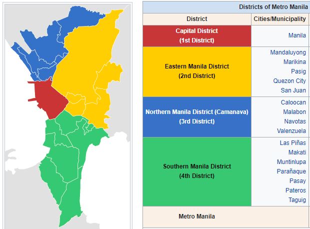
NCR: National Capitol Region:
Even though the NCR is not designated as a region; it is designated Region XIII with the PSGC.
The NCR is made up of the 4 Districts in which the Capitol City of Manila, and 16 cities, and 1 municipality reside.
The National Capital Region (NCR), commonly known as Metro Manila, is the political, economic, and cultural heart of the Philippines. Situated on the eastern shore of Manila Bay in Luzon, it is the most densely populated and urbanized region in the country.
📍 Geography and Composition
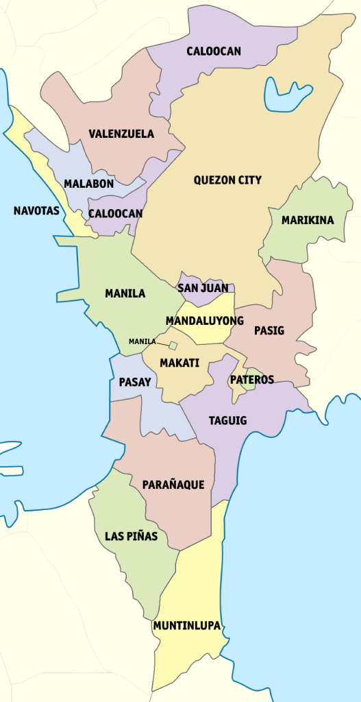
Metro Manila encompasses 16 highly urbanized cities and one municipality:
- Cities: Manila (the capital), Quezon City, Caloocan (divided into north and south), Makati, Taguig, Pasig, Mandaluyong, San Juan, Marikina, Muntinlupa, Las Piñas, Parañaque, Pasay, Malabon, Navotas, and Valenzuela.
- Municipality: Pateros.
Covering an area of approximately 636 square kilometers, the region is bordered by Bulacan to the north, Rizal to the east, Laguna and Cavite to the south, and Manila Bay to the west.
👥 Population and Demographics
As of the 2020 census, Metro Manila had a population of about 13.5 million, making it the second most populous region in the Philippines. When including the surrounding provinces of Bulacan, Cavite, Laguna, and Rizal—collectively known as the Greater Manila Area—the population rises to over 28 million.
💰 Economy
Metro Manila is the country’s economic powerhouse, contributing approximately 36% of the Philippines’ Gross Domestic Product (GDP). The region’s economy is diverse, with key sectors including finance, manufacturing, real estate, and services. Makati City, in particular, is recognized as the financial center, housing the Philippine Stock Exchange and numerous multinational corporations.
🏛️ Governance
The Metropolitan Manila Development Authority (MMDA) oversees the region’s planning, development, and coordination among local government units. The MMDA is led by a chairman and works alongside the Metro Manila Council, which comprises the mayors of the constituent cities and municipality.
🏙️ Urban Landscape and Infrastructure
Metro Manila boasts a mix of historical landmarks and modern developments. Notable areas include:
- Bonifacio Global City (Taguig): A modern business district with skyscrapers and upscale establishments.
- Ortigas Center (Pasig): A central business district known for its commercial and residential spaces.
- Makati Central Business District: The country’s premier financial hub.
The region is served by major transportation arteries like Epifanio de los Santos Avenue (EDSA) and Circumferential Road 5 (C-5), as well as expressways such as the North Luzon Expressway (NLEX) and South Luzon Expressway (SLEX). Public transport includes the Light Rail Transit (LRT) and Metro Rail Transit (MRT) systems.
🎓 Education and Culture
Metro Manila is home to prestigious educational institutions like the University of the Philippines Diliman, Ateneo de Manila University, and De La Salle University. Culturally, the region hosts various museums, theaters, and the Cultural Center of the Philippines, reflecting its rich artistic heritage.
🌍 Global Significance
Designated as a global power city, Metro Manila plays a vital role in international commerce, finance, media, and diplomacy. All foreign embassies in the Philippines are located within the region, underscoring its importance on the global stage.
Please watch Our Blogs on:
Manila and the NCR; City of Manila:
Capital District (1st District):
Eastern Manila District (District 2):
Northern Manila District, (AKA CAMANAVA) District 3:
Southern Manila District (4th District):
| PSGC # Base: | PSGC # | Region # | Region Name: | Province or HUC: | Primary Island: | Founded: | Capitol: | Income Class: | Pop. (2020): | Area (sq. km.): | Area (sq. mi.): | Ind. Cities: | Comp. Cities: | Municipalities | Barangays: | # Island Brys: |
|---|---|---|---|---|---|---|---|---|---|---|---|---|---|---|---|---|
| 13 | 133900000 | N/A | Nation Capitol Region (NCR) | Capitol District (1st District) | Luzon | N/A | Manila | 1st | 1,846,513 | 42.88 | 16.56 | 1 | 0 | N/A | 897 | 0 |
| 13 | 137400000 | N/A | Nation Capitol Region (NCR) | Eastern Manila District (2nd District) | Luzon | N/A | N/A | 1st | 4,782,474 | 236.36 | 91.26 | 1 | 4 | 0 | 236 | 0 |
| 13 | 137500000 | N/A | Nation Capitol Region (NCR) | Northern Manila District (3rd District) | Luzon | N/A | N/A | 1st | 3,004,627 | 126.42 | 48.81 | 0 | 4 | 0 | 255 | 0 |
| 13 | 137600000 | N/A | Nation Capitol Region (NCR) | Southern Manila District (4th District) | Luzon | N/A | N/A | 1st | 3,863,951 | 208.28 | 80.42 | 0 | 6 | 1 | 317 | 0 |
| 13 | 137404000 | N/A | Nation Capitol Region (NCR) | Quezon City | Luzon | 1939 | N/A | 1st | 2,960,048 | 171.71 | 66.30 | 0 | 0 | 0 | 142 | 0 |
| Pop. (2020): | Area (sq. km.): | Area (sq. mi.): | Ind. Cities: | Comp. Cities: | Municipalities: | Barangays: | # Island Brys: | |||||||||
| 13,497,565 | 334.70 | 156.63 | 3 | 14 | 1 | 1,705 | 0 |
Maps of the National Capitol Region:
map from www.morefunwithjuan.com
map from www.morefunwithjuan.com
District 1: Capitol District:
City of Manila; National Capitol of the Philippines.
Philippine Standard Geographical Code # 133900000
District 1 is made up of 14 Areas (almost like municipalities) that are each broken down into 897 barangays.
| PSGC # | Area # | Area Name: | Area: | District: | Pop. (2020): | Pop. (2015): | Barangays: |
|---|---|---|---|---|---|---|---|
| 133901000 | 1 | Tondo I/II | NCR, City of Manila, First District | 1st/2nd | 654,220 | 628,106 | 259 |
| 133902000 | 2 | Binondo | NCR, City of Manila, First District | 3rd | 20,491 | 12,985 | 10 |
| 133903000 | 3 | Quiapo | NCR, City of Manila, First District | 3rd | 29,846 | 24,886 | 16 |
| 133904000 | 4 | San Nicolas | NCR, City of Manila, First District | 3rd | 42,957 | 44,241 | 15 |
| 133905000 | 5 | Santa Cruz | NCR, City of Manila, First District | 3rd | 126,735 | 115,747 | 82 |
| 133906000 | 6 | Sampaloc | NCR, City of Manila, First District | 4th/6th | 388,305 | 341,461 | 243 |
| 133907000 | 7 | San Miguel | NCR, City of Manila, First District | 6th | 18,599 | 15,992 | 12 |
| 133908000 | 8 | Ermita | NCR, City of Manila, First District | 5th | 19,189 | 7,143 | 13 |
| 133909000 | 9 | Intramuros | NCR, City of Manila, First District | 5th | 6,103 | 4,925 | 5 |
| 133910000 | 10 | Malate | NCR, City of Manila, First District | 5th | 99,257 | 77,513 | 57 |
| 133911000 | 11 | Paco | NCR, City of Manila, First District | 5th/6th | 79,839 | 70,978 | 43 |
| 133912000 | 12 | Pandacan | NCR, City of Manila, First District | 6th | 84,769 | 73,895 | 38 |
| 133913000 | 13 | Port Area | NCR, City of Manila, First District | 5th | 72,605 | 57,405 | 5 |
| 133914000 | 14 | Santa Ana | NCR, City of Manila, First District | 5th/6th | 203,598 | 176,894 | 99 |
| CITY OF MANILA | Pop. ( 2020): | Pop. (2015): | Barangays: | ||||
| Totals: | 1,846,513 | 1,652,171 | 897 |
District 2: Eastern Manila District:
Philippine Standard Geographical Code # 137400000
District 2 is broken down into 5 cities and 236 barangays.
| PSGC # | City # | City: | Pop. (2020): | Pop. (2015): | Area (sq km.) | Area (sq mi.) | Barangays: | Income Class: |
|---|---|---|---|---|---|---|---|---|
| 137401000 | 1 | Mandaluyong City | 425,758 | 386,276 | 11.06 | 4.27 | 27 | 1st |
| 137402000 | 2 | Marikina City | 456,059 | 582,602 | 27.36 | 10.56 | 16 | 1st |
| 137403000 | 3 | Pasig City | 803,159 | 755,300 | 31.46 | 12.15 | 30 | 1st |
| 137404000 | 4 | Quezon City | 2,960,048 | 2,936,116 | 165.33 | 63.83 | 142 | spec |
| 137405000 | 5 | San Juan City | 126,347 | 122,180 | 5.87 | 2.27 | 21 | 1st |
| Pop. (2020): | Pop. (2015): | Area (sq km.): | Area (sq mi.): | Barangays: | ||||
| Totals: | 4,771,371 | 4,782,474 | 241.08 | 93.08 | 236 |
District 3: Northern Manila District:
Philippine Standard Geographical Code # 137500000
District 3 is broken down into 4 cities, and 255 barangays.
| PSGC # | City # | City: | Pop. (2020): | Pop. (2015): | Area (sq. km.) | Area (sq. mi.) | Barangays: | Income Class: |
|---|---|---|---|---|---|---|---|---|
| 137501000 | 1 | Caloocan City | 1,661,584 | 1,583,978 | 53.33 | 20.59 | 188 | 1st |
| 137502000 | 2 | Malabon City | 380,522 | 365,525 | 15.96 | 6.16 | 21 | 1st |
| 137503000 | 3 | Navitas City | 247,543 | 249,463 | 11.51 | 4.44 | 14 | 2nd |
| 137504000 | 4 | Valenzuela City | 714,978 | 620,422 | 45.75 | 17.66 | 32 | 1st |
| Pop. (2020): | Pop. (2015): | Area (sq. km.) | Area (sq. mi.) | Barangays: | ||||
| Totals: | 3,004,627 | 2,819,388 | 126.55 | 48.85 | 255 |
District 4: Southern Manila District:
Philippine Standard Geographical Code # 137600000
District 4 is broken down into 6 cities, 1 municipality, and 317 barangays.
| PSGC # | City # | City: | Pop. (2020): | Pop. (2015): | Area (sq. km.) | Area (sq. mi.) | Barangays: | Income Class: |
|---|---|---|---|---|---|---|---|---|
| 137601000 | 1 | Las Pinas City | 606,293 | 588,894 | 32.02 | 12.36 | 20 | 1st |
| 137602000 | 2 | Makati City | 629,616 | 582,602 | 27.36 | 10.56 | 33 | 1st |
| 137603000 | 3 | Muntinlupa City | 543,445 | 504,509 | 41.67 | 16.09 | 9 | 1st |
| 137604000 | 4 | Parañaque City | 689,992 | 664,822 | 47.28 | 18.25 | 16 | 1st |
| 137605000 | 5 | Pasay City | 440,656 | 416,522 | 18.64 | 7.20 | 201 | 1st |
| 137606000 | 6 | Municipality of Pateros | 65,227 | 63,840 | 1.76 | 0.68 | 10 | 1st |
| 137607000 | 7 | Taguig City | 886,722 | 804,915 | 45.18 | 17.44 | 28 | 1st |
| Pop. (2020): | Pop. (2015): | Area (sq. km.) | Area (sq. mi.) | Barangays: | ||||
| Totals: | 3,861,951 | 3,626,104 | 213.91 | 82.58 | 317 |