Region XIII: Caraga Administration Region:
An Informational Overview
Introduction
The Caraga Administrative Region, officially designated as Region XIII, is one of the regions of the Philippines located in the northeastern part of Mindanao. Known for its rich natural resources, diverse culture, and significant contributions to the mining and agricultural sectors, Caraga is an important region in the country’s socioeconomic landscape.
Region XIII: Caraga Administration Region is designated as PSGC # 16 due to the NCR being designated as PSGC # 13, this region is known for its rich cultural heritage and natural resources.
Geographical Location and Provinces
Caraga is strategically located in northeastern Mindanao and is bordered by the Philippine Sea to the east, Northern Mindanao (Region X) to the west, and the Davao Region (Region XI) to the south.
The region comprises five provinces:
The regional center is Butuan City, a highly urbanized city in Agusan del Norte.
Historical Background
The name “Caraga” is believed to have originated from the native word “Kalag”, meaning “spirit” or “soul,” reflective of the early inhabitants known as Kalagans or Caragans. These people were noted for their bravery and strong warrior traditions.
Caraga was officially formed as an administrative region on February 23, 1995, through Republic Act No. 7901. Prior to this, the provinces were part of Region X (Northern Mindanao).
Demographics
As of the latest census, Caraga has a population of over 2.9 million people. The region is home to a mixture of ethnic groups including the Manobo, Mamanwa, Higaonon, and Visayan settlers. Cebuano is the most widely spoken language, along with Surigaonon, Kamayo, and other local dialects.
Economy and Industry
Caraga is known for its abundance of natural resources, which makes it one of the country’s major contributors in:
- Mining – rich in gold, nickel, chromite, and other minerals.
- Forestry – large forest reserves and logging operations.
- Agriculture – producing rice, corn, coconut, banana, and root crops.
- Fisheries and Aquaculture – due to its long coastline and inland waters.
Butuan City also serves as a commercial and trading hub for the region.
Tourism and Natural Attractions
Caraga boasts scenic landscapes, unspoiled beaches, caves, waterfalls, and protected areas. Major attractions include:
- Siargao Island – internationally known as a surfing destination.
- Tinuy-an Falls in Surigao del Sur – often referred to as the “Niagara Falls of the Philippines.”
- Enchanted River in Hinatuan – famous for its deep blue waters and mystical beauty.
- Sohoton Cove in Bucas Grande – featuring lagoons, limestone islets, and caves.
The region is increasingly becoming popular for eco-tourism and adventure tourism.
Infrastructure and Development
Caraga is continuously improving in terms of infrastructure, with developments in transportation (airports, seaports, and roads), communication, and energy. It is also a focus area for development projects aimed at enhancing economic opportunities, especially in remote and indigenous communities.
Culture and Festivals
The region is culturally rich, with numerous festivals and traditions showcasing its indigenous and colonial heritage. Notable festivals include:
- Kahimunan Festival in Butuan City – a celebration of thanksgiving and indigenous culture.
- Bonok-Bonok Festival in Surigao City – a ritual dance honoring tribal heritage and patron saints.
- Naliyagan Festival in Agusan del Sur – celebrating culture, history, and progress.
Conclusion
Caraga Administrative Region is a dynamic and resource-rich area with vast potential in various sectors including tourism, agriculture, and mining. With its natural beauty, cultural diversity, and ongoing development, Caraga is a region of strategic importance and vibrant promise in the Philippines.
| PSGC # Base | PSGC # | Region # | Region Name: | Province or HUC: | Capitol: | Income Class: | Pop. (2020): | Area (sq. km.): | Area (sq. mi.): | Ind. Cities: | Comp. Cities: | Municipalities: | Barangays: | # Island Brys: |
|---|---|---|---|---|---|---|---|---|---|---|---|---|---|---|
| 16 | 160200000 | 13 | Caraga Administration Region | Agusan del Norte | Cabadbaran City | 3rd | 387,503 | 2,730.24 | 1,054.15 | 0 | 1 | 10 | 166 | 0 |
| 16 | 160300000 | 13 | Caraga Administration Region | Agusan del Sur | Prosperidad | 1st | 739,367 | 9,989.52 | 3,856.98 | 0 | 1 | 13 | 314 | 0 |
| 16 | 168500000 | 13 | Caraga Administration Region | Dinagat Islands | San Jose | 4th | 128,117 | 1,036.34 | 400.13 | 0 | 0 | 7 | 100 | 100 |
| 16 | 166700000 | 13 | Caraga Administration Region | Surigao del Norte | Surigao City | 2nd | 534,636 | 1,972.93 | 761.75 | 0 | 1 | 20 | 335 | 158 |
| 16 | 166800000 | 13 | Caraga Administration Region | Surigao del Sur | Tandag City | 1st | 642,255 | 4,932.70 | 1,904.53 | 0 | 2 | 17 | 309 | 2 |
| 16 | 160202000 | 13 | Caraga Administration Region | Butuan City | N/A | 1st | 372,910 | 816.62 | 315.30 | 0 | N/A | N/A | 86 | 0 |
| Pop. (2020): | Area (sq. km.): | Area (sq. mi.): | Ind. Cities: | Comp. Cities: | Municipalities: | Barangays: | # Island Brys: | |||||||
| Totals: | 2,804,788 | 21,478.35 | 8,292.84 | 5 | 67 | 1,310 | 260 |
Map of Region XIII: Caraga Administration Region:
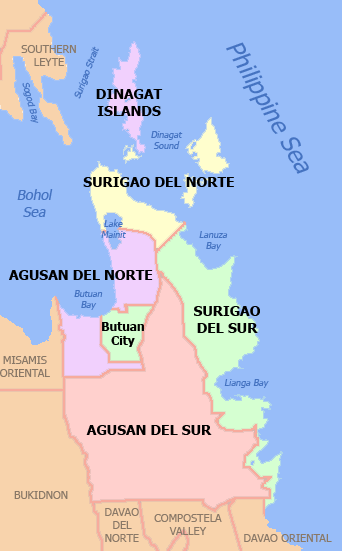
By Namayan at English Wikipedia, CC BY 2.5, https://commons.wikimedia.org/w/index.php?curid=46994544
Provinces of Region XIII: Caraga Administration Region:
Agusan del Norte:
Philippine Standard Geographical Code # 160200000
Agusan del Norte is a coastal province composed of:
| Component City (1): | Municipalities: | Barangay: |
|---|---|---|
| Cabadbaran City (Capitol) | 10 | 252 |
| PSGC # | Town # | Creation Date: | Municipality: | Type: | Coastal/Inland: | Pop. (2020): | Pop. (2015): | Area (sq. km.): | Area (sq. mi.): | IDD: Area Code: | Zip Code: | Barangays: | Income Class: | District: |
|---|---|---|---|---|---|---|---|---|---|---|---|---|---|---|
| 160201000 | 1 | 1/31/1937 | Buenavista | Municipality | Coastal | 68,892 | 61,614 | 475.61 | 183.63 | 63 (0) 85 | 8601 | 25 | 1st Class | II |
| 160202000 | 2 | 1/31/1901 | Butuan City | Independent City | Coastal | 372,910 | 337,063 | 816.62 | 315.30 | 63 (0) 85 | 8600 | 86 | 1st Class | I |
| 160203000 | 3 | 1894 | Cabadbaran City (Capitol) | Component City | Coastal | 80,354 | 73,639 | 214.44 | 82.80 | 63 (0) 85 | 8605 | 31 | 6th Class | II |
| 160204000 | 4 | 7/1/1949 | Carmen | Municipality | Coastal | 23,172 | 20,839 | 311.02 | 120.09 | 63 (0) 85 | 8603 | 8 | 4th Class | II |
| 160205000 | 5 | Jabonga | Municipality | Coastal | 24,855 | 23,184 | 293.00 | 113.13 | 63 (0) 85 | 8607 | 15 | 3rd Class | II | |
| 160206000 | 6 | 8/29/1963 | Kitcharao | Municipality | Coastal | 21,278 | 18,659 | 171.92 | 66.38 | 63 (0) 85 | 8609 | 11 | 4th Class | II |
| 160207000 | 7 | Las Nieves | Municipality | Inland | 30,240 | 28,414 | 582.69 | 224.98 | 63 (0) 85 | 8610 | 20 | 2nd Class | I | |
| 160208000 | 8 | 6/21/1969 | Magallanes | Municipality | Coastal | 22,293 | 21,007 | 44.31 | 17.11 | 63 (0) 85 | 8604 | 8 | 4th Class | II |
| 160209000 | 9 | 8/21/1909 | Nasipit | Municipality | Coastal | 44,822 | 41,957 | 144.40 | 55.75 | 63 (0) 85 | 8602 | 19 | 3rd Class | II |
| 160212000 | 12 | 9/12/1982 | Remedios T. Romualdez ( Mina–Ano) | Municipality | Coastal | 17,155 | 16,058 | 79.15 | 30.56 | 63 (0) 85 | 8611 | 8 | 5th Class | II |
| 160210000 | 10 | 1/31/1937 | Santiago | Municipality | Inland | 28,657 | 24,200 | 275.61 | 106.41 | 63 (0) 85 | 8608 | 8 | 4th Class | II |
| 160211000 | 11 | 6/22/1947 | Tubay | Municipality | Coastal | 25,785 | 24,932 | 138.09 | 53.32 | 63 (0) 85 | 8606 | 13 | 4th Class | II |
| Pop. (2020): | Pop. (2015): | Area (sq. km.): | Area (sq. mi.): | Barangays: | ||||||||||
| Totals: | 760,413 | 691,566.00 | 3,546.86 | 1,369.46 | 252 |
Agusan del Sur:
Philippine Standard Geographical Code # 160300000
Agusan del Sur is a coastal province composed of:
| Component City (1): | Municipalities: | Barangay: |
|---|---|---|
| Bayugan City | 13 | 314 |
| PSGC # | Town # | Creation Date: | Municipality: | Type: | Landlocked: | Pop. (2015): | Pop. (2015): | Area (sq. km.): | Area (sq. mi.): | IDD: Area Code: | Zip Code: | Barangays: | Income Class: | District: |
|---|---|---|---|---|---|---|---|---|---|---|---|---|---|---|
| 160301000 | 1 | 8/20/1961 | Bayugan City | Component City | Landlocked | 109,499 | 103,202 | 688.77 | 265.94 | 63 (0) 85 | 8502 | 43 | 5th Class | I |
| 160302000 | 2 | 1/26/1959 | Bunawan | Municipality | Landlocked | 47,512 | 45,151 | 512.16 | 197.75 | 63 (0) 85 | 8506 | 10 | 1st Class | II |
| 160303000 | 3 | 1921 | Esperanza | Municipality | Landlocked | 59,353 | 54,801 | 1,355.48 | 523.35 | 63 (0) 85 | 8513 | 47 | 1st Class | I |
| 160304000 | 4 | La Paz | Municipality | Landlocked | 30,969 | 28,217 | 1,481.12 | 571.86 | 63 (0) 85 | 8508 | 15 | 1st Class | II | |
| 160305000 | 5 | 3/30/1965 | Loreto | Municipality | Landlocked | 43,880 | 42,501 | 1,462.74 | 564.77 | 63 (0) 85 | 8507 | 17 | 1st Class | II |
| 160306000 | 6 | 1/1/1970 | Prosperidad (Capitol) | Municipality | Landlocked | 88,321 | 82,631 | 505.15 | 195.04 | 63 (0) 85 | 8500 | 32 | 1st Class | I |
| 160307000 | 7 | 6/21/1969 | Rosario | Municipality | Landlocked | 49,610 | 46,683 | 385.05 | 148.67 | 63 (0) 85 | 8504 | 11 | 2nd Class | II |
| 160308000 | 8 | 6/21/1959 | San Francisco | Municipality | Landlocked | 80,760 | 74,542 | 392.53 | 151.56 | 63 (0) 85 | 8501 | 27 | 1st Class | II |
| 160309000 | 9 | 6/15/1968 | San Luis | Municipality | Landlocked | 35,196 | 32,109 | 950.50 | 366.99 | 63 (0) 85 | 8511 | 25 | 1st Class | I |
| 160310000 | 10 | Santa Josefa | Municipality | Landlocked | 26,432 | 26,729 | 341.80 | 131.97 | 63 (0) 85 | 8512 | 11 | 3rd Class | II | |
| 160314000 | 14 | 2/1/1980 | Sibagat | Municipality | Landlocked | 33,957 | 30,442 | 567.82 | 219.24 | 63 (0) 85 | 8503 | 24 | 1st Class | I |
| 160311000 | 11 | Talacogon | Municipality | Landlocked | 39,678 | 38,374 | 405.25 | 156.47 | 63 (0) 85 | 8510 | 16 | 2nd Class | I | |
| 160312000 | 12 | 6/15/1968 | Trento | Municipality | Landlocked | 54,492 | 51,565 | 555.70 | 214.56 | 63 (0) 85 | 8505 | 16 | 1st Class | II |
| 160313000 | 13 | 3/31/1965 | Veruela | Municipality | Landlocked | 39,708 | 43,706 | 385.45 | 148.82 | 63 (0) 85 | 8509 | 20 | 2nd Class | II |
| Pop. (2020): | Pop. (2015): | Area (sq. km.): | Area (sq. mi.): | Barangays: | ||||||||||
| Totals: | 739,367 | 700,653 | 9,989.52 | 3,856.99 | 314 |
Dinagat Islands:
Philippine Standard Geographical Code # 168500000
Dinagat Islands is an island province composed of:
| Municipalities: | Barangay (of which are Island Barangays): |
|---|---|
| 7 | 100 (100) |
| PSGC # | Town # | Creation Date: | Municipality: | Type: | Coastal/Inland: | Island: | Pop. (2020): | Pop. (2015): | Area (sq. km.): | IDD: Area Code: | Zip Code: | Barangays: | Island Bry | Income Class: | District: | |
|---|---|---|---|---|---|---|---|---|---|---|---|---|---|---|---|---|
| 168501000 | 1 | 6/17/1967 | Basilisa (Rizal) | Municipality | Coastal | Dinagat Island + Islands | 36,911 | 36,880 | 92.68 | 35.78 | 63 (0) 86 | 8413 | 27 | 27 | 4th Class | Lone District |
| 168502000 | 2 | 12/23/1959 | Cagdianao | Municipality | Coastal | Dinagat Island | 18,350 | 16,808 | 249.48 | 96.32 | 63 (0) 86 | 8411 | 14 | 14 | 3rd Class | Lone District |
| 168503000 | 3 | 1830 | Dinagat | Municipality | Coastal | Dinagat Island + Island | 10,621 | 10,632 | 139.94 | 54.03 | 63 (0) 86 | 8412 | 12 | 12 | 5th Class | Lone District |
| 168504000 | 4 | 2/29/1960 | Libjo (Albor) | Municipality | Coastal | Dinagat Island + Island | 18,051 | 17,760 | 180.57 | 69.72 | 63 (0) 86 | 8414 | 16 | 16 | 5th Class | Lone District |
| 168505000 | 5 | 1/1/1919 | Loreto | Municipality | Coastal | Dinagat Island + Island | 9,690 | 9,309 | 255.87 | 98.79 | 63 (0) 86 | 8415 | 10 | 10 | 4th Class | Lone District |
| 168506000 | 6 | 11/15/1989 | San Jose (Capitol) | Municipality | Coastal | Dinagat Island | 26,375 | 27,487 | 27.80 | 10.73 | 63 (0) 86 | 8427 | 12 | 12 | 4th Class | Lone District |
| 168507000 | 7 | 6/21/1969 | Tubajon | Municipality | Coastal | Dinagat Island | 8,119 | 8,276 | 90.00 | 34.75 | 63 (0) 86 | 8426 | 9 | 9 | 5th Class | Lone District |
| Pop. (2020): | Pop. (2015): | Area (sq. km.): | Area (sq. mi.): | Barangays: | Island Bry: | |||||||||||
| Totals: | 128,117 | 127,152 | 1,036.34 | 400.12 | 100 | 100 |
Surigao del Norte:
Philippine Standard Geographical Code # 166700000
Surigao del Norte is a coastal province composed of:
| Component City (1): | Municipalities: | Barangay (of which are Island Barangays): |
|---|---|---|
| Surigao City (Capitol) | 20 | 335 (163) |
| PSGC # | Town # | Creation Date: | Municipality: | Type: | Coastal/ Inland: | Mainland/ Island: | Pop. (2020): | Pop. (2015): | Area (sq. km.): | Area (sq. mi.): | IDD: Area Code: | Zip Code: | Barangays: | Island Bry: | Income Class: | District: |
|---|---|---|---|---|---|---|---|---|---|---|---|---|---|---|---|---|
| 166701000 | 1 | Alegria | Municipality | Coastal | Mainland | 16,184 | 16,011 | 65.28 | 25.20 | 63 (0) 86 | 8425 | 12 | 0 | 5th Class | II | |
| 166702000 | 2 | Bacuag | Municipality | Coastal | Mainland | 14,881 | 14,486 | 95.85 | 37.01 | 63 (0) 86 | 8408 | 9 | 0 | 5th Class | II | |
| 166704000 | 3 | Burgos | Municipality | Coastal | Siargo Island | 4,185 | 4,034 | 19.27 | 7.44 | 63 (0) 86 | 8424 | 6 | 6 | 6th Class | I | |
| 166706000 | 4 | 1955 | Claver | Municipality | Coastal | Mainland + Island | 36,033 | 32,773 | 322.60 | 124.56 | 63 (0) 86 | 8410 | 14 | 1 | 1st Class | II |
| 166707000 | 5 | Dapa | Municipality | Coastal | Siargo Island + Islands | 29,006 | 23,787 | 91.90 | 35.48 | 63 (0) 86 | 8417 | 29 | 29 | 4th Class | I | |
| 166708000 | 6 | Del Carmen | Municipality | Coastal | Siargo Island + Island | 20,127 | 18,392 | 151.68 | 58.56 | 63 (0) 86 | 8418 | 20 | 20 | 5th Class | I | |
| 166710000 | 7 | 8/1/1929 | General Luna (Cabuntog) | Municipality | Coastal | Siargo Island + Islands | 22,853 | 16,771 | 41.30 | 15.95 | 63 (0) 86 | 8419 | 19 | 19 | 5th Class | I |
| 166711000 | 8 | 1850 | Gigaquit | Municipality | Coastal | Mainland | 21,849 | 20,864 | 138.11 | 53.32 | 63 (0) 86 | 8409 | 13 | 0 | 4th Class | II |
| 166714000 | 9 | 12/27/1930 | Mainit | Municipality | Coastal | Mainland | 28,019 | 26,741 | 107.76 | 41.61 | 63 (0) 86 | 8417 | 21 | 0 | 4th Class | II |
| 166715000 | 10 | Malimono | Municipality | Coastal | Mainland | 18,852 | 18,054 | 80.13 | 30.94 | 63 (0) 86 | 8402 | 14 | 0 | 5th Class | II | |
| 166716000 | 11 | 10/31/1953 | Pilar | Municipality | Coastal | Siargo Island | 10,374 | 9,752 | 77.11 | 29.77 | 63 (0) 86 | 8420 | 15 | 15 | 5th Class | I |
| 166717000 | 12 | 1850 | Placer | Municipality | Coastal | Mainland + Islands | 29,616 | 27,094 | 61.29 | 23.66 | 63 (0) 86 | 8405 | 20 | 3 | 4th Class | II |
| 166718000 | 13 | San Benito | Municipality | Coastal | Siargo Island + Island | 5,663 | 5,404 | 45.63 | 17.62 | 63 (0) 86 | 8423 | 6 | 6 | 6th Class | I | |
| 166719000 | 14 | 5/24/1957 | San Francisco (Anao-Aon) | Municipality | Coastal | Mainland | 15,347 | 14,552 | 56.72 | 21.90 | 63 (0) 86 | 8401 | 11 | 0 | 5th Class | II |
| 166720000 | 15 | San Isidro | Municipality | Coastal | Siargo Island | 8,519 | 7,325 | 42.03 | 16.23 | 63 (0) 86 | 8421 | 12 | 12 | 5th Class | I | |
| 166721000 | 16 | Santa Monica (Sapao) | Municipality | Coastal | Siargo Island | 9,423 | 8,808 | 39.19 | 15.13 | 63 (0) 86 | 8422 | 11 | 11 | 5th Class | I | |
| 166722000 | 17 | Sison | Municipality | Inland | Mainland | 14,290 | 13,155 | 54.70 | 21.12 | 63 (0) 86 | 8404 | 12 | 0 | 5th Class | II | |
| 166723000 | 18 | 2/22/1961 | Socorro | Municipality | Coastal | Bucas Grande Island | 25,942 | 22,314 | 114.45 | 44.19 | 63 (0) 86 | 8416 | 14 | 14 | 4th Class | I |
| 166724000 | 19 | 6/29/1655 | Surigao City (Capitol) | Component City | Coastal | Mainland + Islands | 171,107 | 154,137 | 245.30 | 94.71 | 63 (0) 86 | 8400 | 54 | 21 | 3rd Class | II |
| 166725000 | 20 | 6/22/1947 | Tagana-an | Municipality | Coastal | Mainland + Islands | 17,323 | 16,428 | 77.29 | 29.84 | 63 (0) 86 | 8403 | 14 | 6 | 5th Class | II |
| 166727000 | 21 | 9/18/1957 | Tubod | Municipality | Inland | Mainland | 15,043 | 14,206 | 45.34 | 17.51 | 63 (0) 86 | 8406 | 9 | 0 | 5th Class | II |
| Pop. (2020): | Pop. (2015): | Area (sq. km.): | Area (sq. mi.): | Barangays: | Island Bry: | |||||||||||
| Totals: | 534,636 | 485,088 | 1,972.93 | 761.75 | 335 | 163 |
Surigao del Sur:
Philippine Standard Geographical Code # 166800000
Surigao del Sur is a coastal province composed of:
| Component City (1): | Municipalities: | Barangay (of which are Island Barangays): |
|---|---|---|
| Bislig City | 28 | 309 (2) |
| Tandag City (Capitol) | N/A | N/A |
| PSGC # | Town # | Creation Date: | Municipality: | Type: | Coastal/ Inland | Pop. (2015): | Pop. (2015): | Area (sq. km.): | Area (sq. mi.): | IDD: Area Code: | Zip Code: | Barangays: | Island Bry: | Income Class: | District: |
|---|---|---|---|---|---|---|---|---|---|---|---|---|---|---|---|
| 166801000 | 1 | 10/24/1960 | Barobo | Municipality | Coastal | 53,146 | 49,730 | 242.50 | 93.63 | 63 (0) 86 | 8309 | 21 | 0 | 3rd Class | II |
| 166802000 | 2 | Bayabas | Municipality | Coastal | 8,979 | 8,164 | 117.84 | 45.50 | 63 (0) 86 | 8303 | 7 | 0 | 5th Class | I | |
| 166803000 | 3 | 1921 | Bislig City | Component City | Coastal | 99,290 | 94,535 | 331.80 | 128.11 | 63 (0) 86 | 8311 | 24 | 0 | 3rd Class | II |
| 166804000 | 4 | 1782 | Cagwait | Municipality | Coastal | 21,747 | 20,384 | 214.10 | 82.66 | 63 (0) 86 | 8304 | 11 | 0 | 4th Class | I |
| 166805000 | 5 | 1782 | Cantilan | Municipality | Coastal + Island | 34,060 | 31,492 | 240.10 | 92.70 | 63 (0) 86 | 8317 | 17 | 1 | 2nd Class | I |
| 166806000 | 6 | 1918 | Carmen | Municipality | Coastal | 11,720 | 10,347 | 160.01 | 61.78 | 63 (0) 86 | 8315 | 8 | 0 | 5th Class | I |
| 166807000 | 7 | Carrascal | Municipality | Coastal | 24,586 | 22,479 | 265.80 | 102.63 | 63 (0) 86 | 8318 | 14 | 0 | 4th Class | I | |
| 166808000 | 8 | 3/19/1954 | Cortes (Kagyunod) | Municipality | Coastal + Island | 17,924 | 15,912 | 127.08 | 49.07 | 63 (0) 86 | 8313 | 12 | 1 | 4th Class | I |
| 166809000 | 9 | Hinatuan | Municipality | Coastal | 43,841 | 39,842 | 299.10 | 115.48 | 63 (0) 86 | 8310 | 24 | 0 | 2nd Class | II | |
| 166810000 | 10 | 12/10/1918 | Lanuza | Municipality | Coastal | 13,642 | 12,001 | 290.60 | 112.20 | 63 (0) 86 | 8314 | 13 | 0 | 4th Class | I |
| 166811000 | 11 | 10/17/1919 | Lianga | Municipality | Coastal | 33,869 | 29,493 | 161.12 | 62.21 | 63 (0) 86 | 8307 | 13 | 0 | 4th Class | I |
| 166812000 | 12 | Lingig | Municipality | Coastal | 35,142 | 31,485 | 305.17 | 117.83 | 63 (0) 86 | 8312 | 18 | 0 | 2nd Class | II | |
| 166813000 | 13 | 2/2/1953 | Madrid | Municipality | Coastal | 16,653 | 15,223 | 141.20 | 54.52 | 63 (0) 86 | 8316 | 14 | 0 | 4th Class | I |
| 166814000 | 14 | Marihatag (Oteiza) | Municipality | Coastal | 19,441 | 18,518 | 312.50 | 120.66 | 63 (0) 86 | 8306 | 12 | 0 | 3rd Class | I | |
| 166815000 | 15 | San Agustin | Municipality | Coastal | 22,855 | 22,779 | 277.28 | 107.06 | 63 (0) 86 | 8305 | 13 | 0 | 4th Class | I | |
| 166816000 | 16 | San Miguel | Municipality | Inland | 41,809 | 39,340 | 558.00 | 215.45 | 63 (0) 86 | 8301 | 18 | 0 | 1st Class | II | |
| 166817000 | 17 | Tagbina | Municipality | Inland | 41,051 | 38,833 | 343.49 | 132.62 | 63 (0) 86 | 8308 | 25 | 0 | 2nd Class | I | |
| 166818000 | 18 | 11/6/1918 | Tago | Municipality | Coastal | 39,831 | 35,329 | 253.28 | 97.79 | 63 (0) 86 | 8302 | 24 | 0 | 2nd Class | I |
| 166819000 | 19 | 1650 | Tandag City (Capitol) | Component City | Coastal | 62,669 | 56,364 | 291.73 | 112.64 | 63 (0) 86 | 8300 | 21 | 0 | 5th Class | I |
| Pop. (2020): | Pop. (2015): | Area (sq. km.): | Area (sq. mi.): | Barangays: | Island Bry: | ||||||||||
| Totals: | 642,255 | 592,250 | 4,932.70 | 1,904.54 | 309 | 2 |