Region XII: SOCCSKSARGEN (Central Mindanao):
SOCCSKSARGEN Region: A Gateway to Southern Mindanao’s Growth and Culture
SOCCSKSARGEN (also known as Central Mindanao), officially designated as Region XII, is one of the 17 administrative regions of the Philippines, located in the south-central part of Mindanao. Its name is an acronym representing its four component provinces and one highly urbanized city: South Cotabato, (North) Cotabato, Sultan Kudarat, and Sarangani, and General Santos City.
Geography and Administrative Divisions
SOCCSKSARGEN is boarded by Region X: Davao (Southern Mindanao) to the east, Region XI: Northern Mindanao to the north, Region XV: Bangsamoro Autonomous Region in Muslim Mindanao (BARMM) to the north-west, the Bay of Moro to the west, and the Sulu Sea to the south.
Provinces and Cities:
- South Cotabato – Home to the regional center, Koronadal City.
- Cotabato (North Cotabato) – A landlocked province known for agriculture and indigenous cultures.
- Sultan Kudarat – Rich in history and natural resources.
- Sarangani – Famous for pristine beaches and marine biodiversity.
- General Santos City – An independent, highly urbanized city known as the “Tuna Capital of the Philippines.”
Demographics and Culture
SOCCSKSARGEN is a melting pot of various ethnic groups, including Hiligaynon/Ilonggo, Cebuano, Maguindanaon, T’boli, and B’laan peoples. This cultural diversity is reflected in the region’s festivals, arts, and crafts.
Major Languages:
- Hiligaynon
- Cebuano
- Tagalog
- Maguindanaon
- English (used in education and official communication)
Notable Festivals:
- T’nalak Festival (South Cotabato) – Celebrates the cultural heritage of the T’boli people.
- Kalilangan Festival (General Santos City) – Highlights the city’s tri-people culture.
- Hinugyaw Festival (Koronadal City) – Marks the founding anniversary of the city with colorful street dancing.
Economy and Industry
SOCCSKSARGEN has a robust and diverse economy, driven by agriculture, aquaculture, trade, and manufacturing. It is considered one of Mindanao’s fastest-growing regions.
Key Economic Sectors:
- Agriculture: Major products include rice, corn, bananas, pineapple, and coconuts.
- Fishing and Aquaculture: General Santos City houses the Philippines’ largest fish port complex.
- Manufacturing: Food processing and agri-industrial businesses are expanding rapidly.
- Tourism: Nature reserves, diving spots, and cultural attractions draw increasing numbers of visitors.
Tourist Attractions
- Lake Sebu (South Cotabato) – A serene lake surrounded by mountains, home to the T’boli tribe.
- Asik-Asik Falls (Cotabato) – A breathtaking curtain-like spring waterfall.
- Gumasa Beach (Sarangani) – Often dubbed the “Boracay of the South.”
- Mt. Matutum – A potentially active volcano and a trekking destination.
- Sarangani Bay – Popular for diving, snorkeling, and dolphin watching.
Infrastructure and Development
The region continues to benefit from infrastructure and investment programs aimed at improving transportation, energy, and education. General Santos International Airport and several seaports serve as major gateways for trade and tourism.
Conclusion
SOCCSKSARGEN Region is a dynamic and culturally rich area that plays a vital role in the development of Mindanao. With its vibrant communities, economic potential, and natural wonders, it stands as a beacon of progress and unity in the southern Philippines.
| PSGC # Base | PSGC # | Region # | Region Name: | Province or HUC: | Capitol: | Income Class: | Pop. (2020): | Area (sq. km.): | Area (sq. mi.): | Ind. Cities: | Comp. Cities: | Municipalities: | Barangays: | # of Island Brys. |
|---|---|---|---|---|---|---|---|---|---|---|---|---|---|---|
| 12 | 124700000 | 12 | SOCCSKSARGEN (Central Mindanao) | Cotabato (Northern Cotabato) | Kidapawan City | 1st | 1,490,618 | 9,008.90 | 3,478.36 | 0 | 1 | 17 | 543 | 0 |
| 12 | 128000000 | 12 | SOCCSKSARGEN (Central Mindanao) | Sarangani | Alabel | 2nd | 558,946 | 3,601.25 | 1,390.45 | 0 | 0 | 7 | 141 | 0 |
| 12 | 126300000 | 12 | SOCCSKSARGEN (Central Mindanao) | South Cotabato | Koronadal City | 1st | 975,476 | 3,935.95 | 1,519.68 | 0 | 1 | 10 | 199 | 0 |
| 12 | 126500000 | 12 | SOCCSKSARGEN (Central Mindanao) | Sultan Kudarat | Isulan | 1st | 854,052 | 5,298.34 | 2,045.70 | 0 | 1 | 11 | 249 | 0 |
| 12 | 129804000 | 12 | SOCCSKSARGEN (Central Mindanao) | Cotabato City | N/A | 2nd | 325,079 | 176.00 | 67.95 | 1 | N/A | N/A | 37 | 0 |
| 12 | 126303000 | 12 | SOCCSKSARGEN (Central Mindanao) | General Santos City | N/A | 1st | 697,315 | 492.86 | 190.29 | 1 | N/A | N/A | 26 | 0 |
| Pop. (2020): | Area (sq. km.): | Area (sq. mi.): | Ind. Cities: | Comp. Cities: | Municipalities: | Barangays: | # of Island Brys. | |||||||
| Totals: | 4,901,486 | 22,513.30 | 8,692.43 | 2 | 3 | 45 | 1,195 | 0 |
Map of Region XII: SOCCSKSARGEN (Central Mindanao):
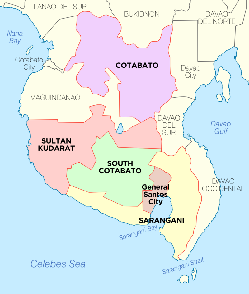
By Exec8 – Own work, CC BY-SA 4.0, https://commons.wikimedia.org/w/index.php?curid=76181384
Provinces of Region XII: SOCCSKSARGEN (Central Mindanao):
Cotabato (Northern Cotabato):
Philippine Standard Geographical Code # 124700000
Cotabato (Northern Cotabato) is a landlocked province composed of:
| Component City (1): | Municipalities: | Barangay: |
|---|---|---|
| Kidapawan City (Capitol) | 13 | 543 |
| PSGC # | Town # | Creation Date: | Municipality: | Type: | Landlocked: | Pop. (2020): | Pop. (2015): | Area (sq. km.): | Area (sq. mi.): | IDD: Area Code: | Zip Code: | Barangays: | Income Class: | District: |
|---|---|---|---|---|---|---|---|---|---|---|---|---|---|---|
| 124701000 | 1 | 5/20/1969 | Alamada | Municipality | Landlocked | 68,659 | 64,596 | 787.50 | 304.06 | 63 (0) 64 | 9413 | 17 | 1st Class | I |
| 124717000 | 17 | 4/6/1982 | Aleosan | Municipality | Landlocked | 41,944 | 39,405 | 225.44 | 87.04 | 63 (0) 64 | 9415 | 19 | 3rd Class | I |
| 124715000 | 15 | 3/7/1981 | Antipas | Municipality | Landlocked | 26,817 | 25,304 | 552.50 | 213.32 | 63 (0) 64 | 9414 | 13 | 2nd Class | II |
| 124718000 | 18 | 8/30/1991 | Arakan | Municipality | Landlocked | 50,558 | 48,228 | 693.22 | 267.65 | 63 (0) 64 | 9417 | 28 | 2nd Class | II |
| 124716000 | 16 | 2/8/1982 | Banisilan | Municipality | Landlocked | 46,995 | 43,677 | 577.22 | 222.87 | 63 (0) 64 | 9416 | 20 | 2nd Class | III |
| 124702000 | 2 | 11/15/1956 | Carmen | Municipality | Landlocked | 107,603 | 95,921 | 1,110.43 | 428.74 | 63 (0) 64 | 9408 | 28 | 1st Class | III |
| 124703000 | 3 | 8/18/1947 | Kabacan | Municipality | Landlocked | 93,822 | 89,161 | 448.09 | 173.01 | 63 (0) 64 | 9407 | 24 | 1st Class | III |
| 124704000 | 4 | 8/18/1947 | Kidapawan City (Capitol) | Component City | Landlocked | 160,791 | 140,195 | 358.47 | 138.41 | 63 (0) 64 | 9400 | 40 | 3rd Class | II |
| 124705000 | 5 | 1/27/1968 | Libungan | Municipality | Landlocked | 56,269 | 48,768 | 172.50 | 66.60 | 63 (0) 64 | 9411 | 20 | 2nd Class | I |
| 124706000 | 6 | 6/22/1963 | Magpet | Municipality | Landlocked | 53,800 | 49,201 | 755.36 | 291.65 | 63 (0) 64 | 9404 | 32 | 1st Class | II |
| 124707000 | 7 | 9/8/1954 | Makilala | Municipality | Landlocked | 87,927 | 83,851 | 343.57 | 132.65 | 63 (0) 64 | 9401 | 38 | 1st Class | II |
| 124708000 | 8 | 12/29/1961 | Matalam | Municipality | Landlocked | 81,355 | 79,361 | 476.00 | 183.78 | 63 (0) 64 | 9406 | 34 | 1st Class | III |
| 124709000 | 9 | 11/25/1936 | Midsayap | Municipality | Landlocked | 165,376 | 151,684 | 290.42 | 112.13 | 63 (0) 64 | 9410 | 57 | 1st Class | I |
| 124710000 | 10 | 8/3/1951 | M’lang | Municipality | Landlocked | 98,195 | 95,070 | 312.13 | 120.51 | 63 (0) 64 | 9402 | 37 | 1st Class | III |
| 124711000 | 11 | 9/30/1953 | Pigcawayan | Municipality | Landlocked | 72,371 | 66,796 | 340.11 | 131.32 | 63 (0) 64 | 9412 | 40 | 1st Class | I |
| 124712000 | 12 | 6/17/1913 | Pikit | Municipality | Landlocked | 164,646 | 154,441 | 604.61 | 233.44 | 63 (0) 64 | 9409 | 42 | 1st Class | I |
| 124713000 | 13 | 5/8/1967 | President Roxas | Municipality | Landlocked | 52,512 | 47,575 | 618.25 | 238.71 | 63 (0) 64 | 9405 | 25 | 1st Class | II |
| 124714000 | 14 | 8/6/1961 | Tulunan | Municipality | Landlocked | 60,978 | 56,513 | 343.08 | 132.46 | 63 (0) 64 | 9403 | 29 | 2nd Class | III |
| Pop. (2020): | Pop. (2015): | Area (sq. km.): | Area (sq. mi.): | Barangays: | ||||||||||
| Totals: | 1,490,618 | 1,379,747.00 | 9,008.90 | 3,478.35 | 543 |
Sarangani:
Philippine Standard Geographical Code # 128000000
Sarangani is a coastal province composed of:
| Municipalities: | Barangay: |
|---|---|
| 7 | 141 |
| PSGC # | Town # | Creation Date: | Municipality: | Type: | Area: | Coastal/Inland | Pop. (2020): | Pop. (2015): | Area (sq. km.): | Area (sq. mi.): | IDD: Area Code: | Zip Code: | Barangays: | Income Class: | District: |
|---|---|---|---|---|---|---|---|---|---|---|---|---|---|---|---|
| 128001000 | 1 | Alabel (Capitol) | Municipality | Eastern Portion | Coastal | 88,294 | 80,359 | 510.98 | 197.29 | 63 (0) 63 | 9501 | 13 | 1st Class | Lone District | |
| 128002000 | 2 | Glan | Municipality | Eastern Portion | Coastal | 109,547 | 118,263 | 610.30 | 235.64 | 63 (0) 63 | 9517 | 31 | 1st Class | Lone District | |
| 128003000 | 3 | 8/18/1947 | Kiamba | Municipality | Western Portion | Coastal | 65,774 | 61,058 | 328.68 | 126.90 | 63 (0) 63 | 9514 | 19 | 1st Class | Lone District |
| 128004000 | 4 | Maasim | Municipality | Western Portion | Coastal | 64,940 | 59,468 | 500.43 | 193.22 | 63 (0) 63 | 9502 | 16 | 1st Class | Lone District | |
| 128005000 | 5 | 5/7/1959 | Maitum | Municipality | Western Portion | Coastal | 44,185 | 44,595 | 290.66 | 112.22 | 63 (0) 63 | 9515 | 19 | 2nd Class | Lone District |
| 128006000 | 6 | Malapatan | Municipality | Eastern Portion | Coastal | 80,741 | 76,914 | 609.28 | 235.24 | 63 (0) 63 | 9516 | 12 | 1st Class | Lone District | |
| 128007000 | 7 | Malungon | Municipality | Eastern Portion | Inland | 105,465 | 103,604 | 750.92 | 289.93 | 63 (0) 63 | 9503 | 31 | 1st Class | Lone District | |
| Pop. (2020): | Pop. (2015): | Area (sq. km.): | Area (sq. mi.): | Barangays: | |||||||||||
| Totals: | 558,946 | 544,261 | 3,601.25 | 1,390.44 | 141 |
South Cotabato:
Philippine Standard Geographical Code # 126300000
South Cotabato is a coastal province composed of:
| Independent City (1): | Component City (1): | Municipalities: | Barangay: |
|---|---|---|---|
| General Santos City | Koronadal City (Capitol) | 10 | 225 |
| PSGC # | Town # | Creation Date: | Municipality: | Type: | Coastal/Inland: | Pop. (2020): | Pop. (2015): | Area (sq. km.): | Area (sq. mi.): | IDD: Area Code: | Zip Code: | Barangays: | Income Class: | District: |
|---|---|---|---|---|---|---|---|---|---|---|---|---|---|---|
| 126302000 | 1 | 9/11/1953 | Banga | Municipality | Inland | 89,164 | 83,989 | 240.35 | 92.80 | 63 (0) 83 | 9511 | 22 | 1st Class | II |
| 126303000 | 2 | 8/18/1947 | General Santos City (Dadiangas) | Independent City | Coastal | 697,315 | 594,446 | 492.86 | 190.29 | 63 (0) 83 | 9500 | 26 | 1st Class | I |
| 126306000 | 3 | 1/10/1939 | Koronadal City (Capitol) | Component City | Inland | 195,398 | 174,942 | 277.00 | 106.95 | 63 (0) 83 | 9506 | 27 | 3rd Class | II |
| 126319000 | 12 | Lake Sebu | Municipality | Inland | 81,221 | 87,442 | 702.00 | 271.04 | 63 (0) 83 | 9506 | 19 | 1st Class | II | |
| 126311000 | 4 | Norala | Municipality | Inland | 46,682 | 46,642 | 123.20 | 47.57 | 63 (0) 83 | 9508 | 14 | 3rd Class | II | |
| 126312000 | 5 | 9/10/1957 | Polomolok | Municipality | Inland | 172,605 | 152,589 | 339.97 | 131.26 | 63 (0) 83 | 9504 | 23 | 1st Class | I |
| 126318000 | 11 | 4/7/1981 | Santo Niño | Municipality | Inland | 89,340 | 40,947 | 86.20 | 33.28 | 63 (0) 83 | 9509 | 10 | 3rd Class | II |
| 126313000 | 6 | 6/18/1961 | Surallah | Municipality | Inland | 41,018 | 84,539 | 540.30 | 208.61 | 63 (0) 83 | 9512 | 17 | 1st Class | II |
| 126314000 | 7 | Tampakan | Municipality | Inland | 45,744 | 39,525 | 390.00 | 150.58 | 63 (0) 83 | 9507 | 14 | 2nd Class | I | |
| 126315000 | 8 | Tantangan | Municipality | Inland | 101,049 | 43,245 | 351.12 | 135.57 | 63 (0) 83 | 9510 | 13 | 3rd Class | II | |
| 126316000 | 9 | T’boli | Municipality | Inland | 73,459 | 91,453 | 895.83 | 345.88 | 63 (0) 83 | 9513 | 25 | 1st Class | II | |
| 126317000 | 10 | Tupi | Municipality | Inland | 39,796 | 69,976 | 228.00 | 88.03 | 63 (0) 83 | 9505 | 15 | 1st Class | I | |
| Pop. (2020): | Pop. (2015): | Area (sq. km.): | Area (sq. mi.): | Barangays: | ||||||||||
| Totals: | 1,672,791 | 1,509,735 | 4,666.83 | 1,801.86 | 225 |
Sultan Kudarat:
Philippine Standard Geographical Code # 126500000
Ilocos Norte is a coastal province composed of:
| Component City (1): | Municipalities: | Barangay: |
|---|---|---|
| Tacurong City | 10 | 249 |
| PSGC # | Town # | Creation Date: | Municipality: | Type: | Coastal/Inland: | Pop. (2020): | Pop. (2015): | Area (sq. km.): | Area (sq. mi.): | IDD: Area Code: | Zip Code: | Barangays: | Income Class: | District: |
|---|---|---|---|---|---|---|---|---|---|---|---|---|---|---|
| 126501000 | 1 | 11/22/1973 | Bagumbayan | Municipality | Inland | 68,947 | 67,061 | 672.06 | 259.48 | 63 (0) 64 | 9810 | 19 | 1st Class | II |
| 126502000 | 2 | 11/22/1973 | Columbio | Municipality | Inland | 33,527 | 33,258 | 926.15 | 357.59 | 63 (0) 64 | 9801 | 16 | 1st Class | I |
| 126503000 | 3 | 6/21/1959 | Esperanza | Municipality | Inland | 74,696 | 66,095 | 324.29 | 125.21 | 63 (0) 64 | 9806 | 19 | 1st Class | II |
| 126504000 | 4 | 8/30/1957 | Isulan (Capitol) | Municipality | Inland | 97,490 | 90,682 | 541.25 | 208.98 | 63 (0) 64 | 9805 | 17 | 1st Class | I |
| 126505000 | 5 | 1961 | Kalamansig | Municipality | Coastal | 50,900 | 49,059 | 699.20 | 269.96 | 63 (0) 64 | 9808 | 15 | 1st Class | II |
| 126508000 | 8 | 11/11/1973 | Lambayong (Mariano Marcos) | Municipality | Inland | 79,739 | 77,013 | 226.88 | 87.60 | 63 (0) 64 | 9802 | 26 | 2nd Class | I |
| 126506000 | 6 | 8/18/1947 | Lebak | Municipality | Coastal | 91,344 | 88,868 | 470.86 | 181.80 | 63 (0) 64 | 9807 | 27 | 1st Class | II |
| 126507000 | 7 | 1966 | Lutayan | Municipality | Inland | 65,644 | 63,029 | 271.00 | 104.63 | 63 (0) 64 | 9803 | 11 | 2nd Class | I |
| 126509000 | 9 | 8/14/1959 | Palimbang | Municipality | Coastal | 92,828 | 90,424 | 484.85 | 187.20 | 63 (0) 64 | 9809 | 40 | 2nd Class | II |
| 126510000 | 10 | 11/22/1973 | President Quirino | Municipality | Inland | 42,244 | 41,408 | 208.40 | 80.46 | 63 (0) 64 | 9804 | 19 | 3rd Class | I |
| 126512000 | 12 | 2/17/1989 | Senator Ninoy Aquino | Municipality | Inland | 47,374 | 46,882 | 320.00 | 123.55 | 63 (0) 64 | 9811 | 20 | 3rd Class | II |
| 126511000 | 11 | 8/3/1951 | Tacurong City | Component City | Inland | 109,319 | 98,316 | 153.40 | 59.23 | 63 (0) 64 | 9800 | 20 | 3rd Class | I |
| Pop. (2020): | Pop. (2015): | Area (sq. km.): | Area (sq. mi.): | Barangays: | ||||||||||
| Totals: | 854,052 | 812,095 | 5,298.34 | 2,045.69 | 249 |