Province of Davao Occidental:
Philippine Standard Geographical Code # 118600000
Davao Occidental is the 81st province of the Philippines and was carved out of the southwestern part of Davao del Sur. Established on October 28, 2013, by virtue of Republic Act No. 10360, it comprises five municipalities: its provincial capital, Malita, Don Marcelino, Jose Abad Santos, Santa Maria, and Sarangani.
The creation of Davao Occidental aimed at enhancing administrative governance, speeding up social and economic development, and providing better service delivery to the local populace. This region boasts an idyllic landscape with a mix of coastal areas and highland territories, offering both agricultural and marine resources abundantly.
Davao Occidental is geographically significant; it faces the Celebes Sea to the South, which is part of the Coral Triangle, an area known for its extraordinary marine biodiversity. The province offers a range of activities for eco-tourism enthusiasts, such as diving, snorkeling, and hiking. Its untouched coral reefs and diverse marine life make it an ideal spot for conservation efforts and sustainable tourism ventures.
The province’s economy primarily revolves around agriculture, with coconut, banana, and corn as the leading products. Fishing also plays a substantial role, with the Celebes Sea providing an abundant source of fish and other seafood. Despite its rich natural resources, Davao Occidental is determined to balance economic progress with environmental preservation.
Culturally, Davao Occidental is a melting pot, with various indigenous communities, such as the B’laan and the Manobo, as well as Christians and Muslims living together. The province celebrates the “Kasadya sa Sarangani Bay Festival,” a vibrant event marked by street dancing, cultural presentations, and sports activities, reflecting the rich heritage and local traditions.
The challenge for Davao Occidental lies in its relative infancy as a province, with the need for infrastructure development, healthcare improvements, and enhanced educational facilities. Given its strategic location, the local government envisions transforming it into a gateway for trade and tourism in the region.
Davao Occidental offers a glimpse of the Philippines’ untouched beauty and potential for growth. With prudent management and sustainable practices, it stands on the brink of becoming a significant player in regional development and a beacon of eco-tourism in Mindanao.
Davao Occidental is a coastal province, is composed of:
| Municipalities: | Barangay (of which are Island Barangays): |
|---|---|
| 5 | 105 (12) |
Map of Davao Occidental:
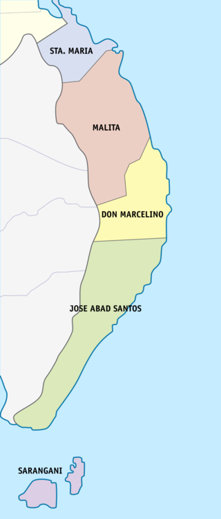
By HueMan1 – Own work, CC BY-SA 4.0, https://commons.wikimedia.org/w/index.php?curid=79244045
Municipalities:
Don Marcelino: Municipality
Philippine Standard Geographical Code # 118601000
2020 Population: 45,540
| PSGC # | Bry # | Barangay Name: | Rural/Urban: | Pop. (2020): | Pop. (2015): | Hectares sq: | Coastal/Inland: |
| 118601007 | Baluntaya | Rural | 2,416 | 2,450 | Inland | ||
| 118601001 | Calian | Rural | 3,709 | 3,854 | Coastal | ||
| 118601008 | Dalupan | Rural | 3,479 | 3,479 | Inland | ||
| 118601009 | Kinanga | Rural | 4,012 | 3,860 | Coastal | ||
| 118601002 | Kiobog | Rural | 2,015 | 2,276 | Coastal | ||
| 118601003 | Lamidan North | Rural | 2,036 | 2,041 | Coastal | ||
| 118601014 | Lamidan South | Rural | 1,654 | 1,700 | Coastal | ||
| 118601015 | Lamidan West | Rural | 2,984 | 2,846 | Inland | ||
| 118601010 | Lanao | Rural | 1,135 | 1,044 | Coastal | ||
| 118601011 | Lapuan | Rural | 5,061 | 4,944 | Inland | ||
| 118601004 | Lawa (Pob.) | Rural | 4,041 | 3,269 | Población-Coastal | ||
| 118601012 | Linadasan | Rural | 1,836 | 1,751 | Coastal | ||
| 118601013 | Mabuhay | Rural | 2,138 | 2,093 | Inland | ||
| 118601005 | Nueva Villa | Rural | 2,079 | 2,049 | Inland | ||
| 118601006 | Talagutong (Pob.) | Urban | 6,945 | 6,898 | Población-Coastal | ||
| Pop. (2020): | Pop. (2015): | ||||||
| 45,540 | 44,554 |
Jose Abad Santos (Trinidad): Municipality
Philippine Standard Geographical Code # 118602000
2020 Population: 73,381
| PSGC # | Bry # | Barangay Name: | Rural/Urban: | Pop. (2020): | Pop. (2015): | Hectares sq: | Coastal/Inland: |
| 118602002 | Balangonan | Rural | 3,085 | 3,075 | Coastal | ||
| 118602001 | Buguis | Rural | 1,313 | 1,601 | Coastal | ||
| 118602006 | Bukid | Rural | 2,822 | 2,801 | Inland | ||
| 118602007 | Butuan | Rural | 2,172 | 2,060 | Coastal | ||
| 118602008 | Butulan | Rural | 2,891 | 2,840 | Coastal | ||
| 118602009 | Caburan Big | Rural | 4,827 | 5,280 | Coastal | ||
| 118602010 | Caburan Small (Pob.) | Urban | 7,017 | 6,734 | Población-Coastal | ||
| 118602011 | Camalian | Rural | 1,769 | 1,754 | Coastal | ||
| 118602012 | Carahayan | Rural | 2,448 | 1,986 | Coastal | ||
| 118602013 | Cayaponga | Rural | 1,882 | 2,078 | Coastal | ||
| 118602014 | Culaman | Rural | 3,265 | 3,805 | Coastal | ||
| 118602015 | Kalbay | Rural | 4,302 | 4,380 | Coastal | ||
| 118602016 | Kitayo | Rural | 1,122 | 1,192 | Inland | ||
| 118602019 | Magulibas | Rural | 2,714 | 2,457 | Coastal | ||
| 118602020 | Malalan | Rural | 2,374 | 2,440 | Coastal | ||
| 118602021 | Mangile | Rural | 3,249 | 3,260 | Coastal | ||
| 118602022 | Marabutuan | Rural | 4,292 | 4,586 | Coastal | ||
| 118602023 | Meybio | Rural | 2,284 | 2,223 | Coastal | ||
| 118602024 | Molmol | Rural | 2,258 | 2,418 | Inland | ||
| 118602025 | Nuing | Rural | 3,089 | 3,260 | Coastal | ||
| 118602026 | Patulang | Rural | 1,542 | 1,854 | Coastal | ||
| 118602027 | Quiapo | Rural | 1,886 | 2,112 | Inland | ||
| 118602028 | San Isidro | Rural | 2,195 | 2,914 | Inland | ||
| 118602033 | Sugal | Rural | 2,944 | 3,392 | Coastal | ||
| 118602034 | Tabayon | Rural | 3,394 | 3,267 | Coastal | ||
| 118602035 | Tanuman | Rural | 2,245 | 2,563 | Coastal | ||
| Pop. (2020): | Pop. (2015): | ||||||
| 73,381 | 76,332 |
Malita: Municipality and Capitol of Davao Occidental
Philippine Standard Geographical Code # 118603000
2020 Population: 118,197
| PSGC # | Bry # | Barangay Name: | Rural/Urban: | Pop. (2020): | Pop. (2015): | Hectares sq: | Coastal/Inland: |
| 118603001 | Bito | Rural | 1,886 | 1,864 | Inland | ||
| 118603002 | Bolila | Rural | 1,970 | 2,076 | Inland | ||
| 118603003 | Buhangin | Rural | 4,637 | 4,194 | Inland | ||
| 118603004 | Culaman | Rural | 1,982 | 1,781 | Coastal | ||
| 118603005 | Datu Danwata | Urban | 5,993 | 6,386 | Inland | ||
| 118603006 | Demoloc | Urban | 6,156 | 7,239 | Inland | ||
| 118603007 | Felis | Rural | 2,889 | 2,702 | Inland | ||
| 118603008 | Fishing Village (Fisherman’s Village) | Rural | 3,611 | 3,656 | Coastal | ||
| 118603010 | Kibalatong | Rural | 1,273 | 1,296 | Coastal | ||
| 118603011 | Kidalapong | Rural | 2,512 | 2,156 | Inland | ||
| 118603012 | Kilalag | Rural | 3,297 | 2,997 | Inland | ||
| 118603013 | Kinangan | Rural | 2,897 | 3,941 | Inland | ||
| 118603016 | Lacaron | Urban | 4,179 | 3,038 | Inland | ||
| 118603017 | Lagumit | Rural | 5,516 | 4,528 | Inland | ||
| 118603018 | Lais | Rural | 1,980 | 1,781 | Inland | ||
| 118603022 | Little Baguio | Urban | 12,201 | 11,317 | Inland | ||
| 118603023 | Macol | Rural | 1,381 | 1,817 | Inland | ||
| 118603024 | Mana | Rural | 4,221 | 4,201 | Coastal | ||
| 118603025 | Manuel Peralta | Rural | 2,646 | 3,038 | Inland | ||
| 118603027 | New Argao | Rural | 1,659 | 1,611 | Coastal | ||
| 118603041 | Pangaleon | Rural | 2,259 | 2,286 | Inland | ||
| 118603030 | Pangian | Rural | 3,650 | 4,142 | Coastal | ||
| 118603031 | Pinalpalan | Rural | 4,287 | 4,686 | Inland | ||
| 118603032 | Población | Urban | 19,079 | 17,787 | Población-Coastal | ||
| 118603033 | Sangay | Rural | 3,334 | 3,745 | Inland | ||
| 118603036 | Talogoy | Rural | 2,433 | 3,003 | Inland | ||
| 118603037 | Tical | Rural | 1,086 | 1,230 | Inland | ||
| 118603038 | Ticulon | Rural | 2,597 | 2,835 | Inland | ||
| 118603039 | Tingolo | Rural | 2,124 | 2,090 | Coastal | ||
| 118603040 | Tubalan | Rural | 4,462 | 4,323 | Coastal | ||
| Pop. (2020): | Pop. (2015): | ||||||
| 118,197 | 117,746 |
Santa Maria: Municipality
Philippine Standard Geographical Code # 118604000
2020 Population: 57,526
| PSGC # | Bry # | Barangay Name: | Rural/Urban: | Pop. (2020): | Pop. (2015): | Hectares sq: | Coastal/Inland: |
| 118604001 | Basiawan | Urban | 7,604 | 7,465 | Coastal | ||
| 118604002 | Buca | Rural | 2,422 | 2,985 | Inland | ||
| 118604003 | Cadaatan | Rural | 1,947 | 1,804 | Inland | ||
| 118604021 | Datu Daligasao | Rural | 841 | 883 | Inland | ||
| 118604022 | Datu Intan | Rural | 1,539 | 1,253 | Inland | ||
| 118604004 | Kidadan | Rural | 1,084 | 1,441 | Inland | ||
| 118604023 | Kinilidan | Rural | 1,233 | 826 | Inland | ||
| 118604005 | Kisulad | Rural | 1,317 | 1,295 | Coastal | ||
| 118604006 | Malalag Tubig | Rural | 980 | 1,009 | Inland | ||
| 118604007 | Mamacao | Rural | 3,011 | 2,899 | Coastal | ||
| 118604008 | Ogpao | Rural | 1,190 | 1,144 | Coastal | ||
| 118604009 | Población | Urban | 10,120 | 8,108 | Población-Inland | ||
| 118604010 | Pongpong | Rural | 2,168 | 2,515 | Inland | ||
| 118604011 | San Agustin | Rural | 5,222 | 4,721 | Coastal | ||
| 118604012 | San Antonio | Rural | 2,478 | 2,354 | Inland | ||
| 118604013 | San Isidro | Rural | 2,955 | 2,576 | Inland | ||
| 118604014 | San Juan | Rural | 1,522 | 1,587 | Inland | ||
| 118604015 | San Pedro | Rural | 2,058 | 1,658 | Inland | ||
| 118604016 | San Roque | Rural | 1,658 | 1,489 | Inland | ||
| 118604019 | Santo Niño | Rural | 1,603 | 1,714 | Inland | ||
| 118604020 | Santo Rosario | Rural | 1,466 | 1,239 | Coastal | ||
| 118604018 | Tanglad | Rural | 3,108 | 2,706 | Coastal | ||
| Pop. (2020): | Pop. (2015): | ||||||
| 57,526 | 53,671 |
Sarangani (Sarangani & Balut Islands): Municipality
Philippine Standard Geographical Code # 118605000
2020 Population: 22,515
| PSGC # | Bry # | Barangay Name: | Rural/Urban: | Pop. (2020): | Pop. (2015): | Hectares sq: | Coastal/Inland: | Island: |
| 118605001 | Batuganding | Rural | 2,209 | 2,200 | Coastal | Balut Island | ||
| 118605008 | Camahual | Rural | 1,205 | 1,262 | Coastal | Sarangani Island | ||
| 118605009 | Camalig | Rural | 1,160 | 1,166 | Coastal | Sarangani Island | ||
| 118605010 | Gomtago | Rural | 895 | 797 | Coastal | Balut Island | ||
| 118605002 | Konel | Rural | 2,142 | 2,140 | Coastal | Balut Island | ||
| 118605003 | Lipol | Rural | 1,625 | 2,173 | Coastal | Balut Island | ||
| 118605004 | Mabila (Pob.) | Urban | 5,253 | 5,147 | Población-Coastal | Balut Island | ||
| 118605005 | Sarangani Norte (Patuco) | Rural | 2,781 | 2,942 | Coastal | Sarangani Island | ||
| 118605006 | Sarangani Sur (Laker) | Rural | 1,524 | 1,797 | Coastal | Sarangani Island | ||
| 118605011 | Tagen | Rural | 1,397 | 1,563 | Coastal | Balut Island | ||
| 118605007 | Tinina | Rural | 1,439 | 1,861 | Coastal | Balut Island | ||
| 118605012 | Tucal | Rural | 885 | 991 | Coastal | Balut Island | ||
| Pop. (2020): | Pop. (2015): | |||||||
| 22,515 | 24,039 |