Region III: Central Luzon Region:
The Rice Granary of the Philippines
Overview
Central Luzon, officially designated as Region III, is one of the 17 regions of the Philippines. It is located in the central part of Luzon Island, the country’s largest and most populous island. Known as the “Rice Granary of the Philippines,” Central Luzon plays a vital role in the nation’s agriculture, economy, and history.
Geographical Location
The Central Luzon Region spans the width of the island with Bataan and Zambales on the west coast; Bulacan on the Manila Bay; and Aurora on the east coast. Nueva Ecija, Pampanga, and Tarlac are landlocked.
Central Luzon is situated north of Metro Manila and is bordered by:
- Ilocos Region (Region I) and Cordillera Administrative Region (CAR) to the north,
- Cagayan Valley (Region II) to the northeast,
- CALABARZON (Region IV-A) to the south,
- The West Philippine Sea to the west,
- And the Philippine Sea to the east.
Provinces and Cities
Central Luzon is composed of seven provinces and three highly urbanized cities:
Provinces:
Highly Urbanized Cities:
- Angeles City
- Olongapo City
- San Jose del Monte
The regional center is City of San Fernando in Pampanga.
Demographics
As of the latest census, Central Luzon is one of the most populous regions in the country, with millions of residents. The region is predominantly Tagalog- and Kapampangan-speaking, with Ilocano, Pangasinense, and Sambal also spoken in various areas.
Economy
Central Luzon has a diverse economy with strong agricultural, industrial, and service sectors:
- Agriculture: Known for vast rice fields, especially in Nueva Ecija, it produces a significant portion of the country’s rice.
- Industry: The region is home to large industrial estates, especially in Bataan and Pampanga.
- Commerce and Services: With its proximity to Metro Manila and improved infrastructure, commercial development has been robust.
Tourism and Attractions
Central Luzon boasts a mix of natural beauty, historical landmarks, and cultural heritage:
- Mount Pinatubo (Zambales): A famous volcano with a beautiful crater lake.
- Subic Bay Freeport Zone (Zambales): A former U.S. naval base turned into a bustling economic and tourism hub.
- Clark Freeport Zone (Pampanga): A center for business, aviation, and tourism.
- Aurora’s Beaches: Baler is popular for surfing and beach tourism.
- Historical Sites: Such as the Barasoain Church in Bulacan, known as the birthplace of the First Philippine Republic.
Infrastructure
The region is well-connected through major expressways like the North Luzon Expressway (NLEX), Subic-Clark-Tarlac Expressway (SCTEX), and Central Luzon Link Expressway (CLLEX). The Clark International Airport serves as a growing aviation hub in the region.
Education
Central Luzon is home to reputable educational institutions, including:
- Central Luzon State University (CLSU) in Nueva Ecija
- Tarlac State University
- Bulacan State University
- Holy Angel University in Angeles City
Culture and Festivals
The region is rich in cultural traditions and festivals:
- Giant Lantern Festival (Pampanga)
- Singkaban Festival (Bulacan)
- Tsinelas Festival (Gapan, Nueva Ecija)
Central Luzon serves as a dynamic bridge between the country’s capital and the northern provinces. With its strategic location, fertile lands, and vibrant communities, it continues to play a crucial role in the development of the Philippines.
| PSGC # Base: | PSGC # | Region # | Province or HUC: | Primary Island: | Founded: | Capitol: | Income Class: | Pop. (2020): | Area (sq. km.): | Area (sq. mi.): | Ind. Cities: | Comp. Cities: | Municipalities: | Barangays: | # Island Brys: |
|---|---|---|---|---|---|---|---|---|---|---|---|---|---|---|---|
| 3 | 37700000 | 3 | Aurora | Luzon | 8/13/1979 | Baler | 3rd | 235,750 | 3,147.32 | 1,215.19 | 0 | 0 | 8 | 151 | 0 |
| 3 | 30800000 | 3 | Bataan | Luzon | 1754 | Balanga City | 1st | 853,373 | 1,372.98 | 530.11 | 0 | 1 | 11 | 237 | 0 |
| 3 | 31400000 | 3 | Bulacan | Luzon | 8/15/1578 | Malolos City | 1st | 3,708,890 | 2,796.10 | 1,079.58 | 0 | 4 | 20 | 569 | 0 |
| 3 | 34900000 | 3 | Nueva Ecija | Luzon | 4/25/1801 | Palayan | 1st | 2,310,134 | 5,751.33 | 2,220.60 | 0 | 5 | 27 | 849 | 0 |
| 3 | 35400000 | 3 | Pampanga | Luzon | 12/11/1571 | San Fernando City | 1st | 2,437,709 | 2,002.20 | 773.05 | 1 | 2 | 19 | 505 | 0 |
| 3 | 36900000 | 3 | Tarlac | Luzon | 1872 | Tarlac City | 1st | 1,503,456 | 3,053.60 | 1,179.00 | 0 | 1 | 17 | 511 | 0 |
| 3 | 37100000 | 3 | Zambales | Luzon | 1578 | Iba | 2nd | 649,615 | 3,645.83 | 1,407.66 | 1 | 0 | 13 | 230 | 4 |
| 3 | 35401000 | 3 | Angeles City, Pampanga | Luzon | 1/1/1964 | N/A | 1st | 462,928 | 60.27 | 23.27 | N/A | N/A | N/A | 33 | 0 |
| 3 | 37107000 | 3 | Olongapo City, Zambales | Luzon | 6/1/1966 | N/A | 1st | 260,317 | 185.00 | 71.43 | N/A | N/A | N/A | 17 | 0 |
| Pop. (2020): | Area (sq. km.): | Area (sq. mi.): | Ind. Cities: | Comp. Cities: | Muncipalities: | Barangays: | # Island Brys: | ||||||||
| Totals: | 12,422,172 | 22,014.63 | 8,499.89 | 2 | 13 | 115 | 3,102 | 4 |
Map of Region III: Central Luzon Region
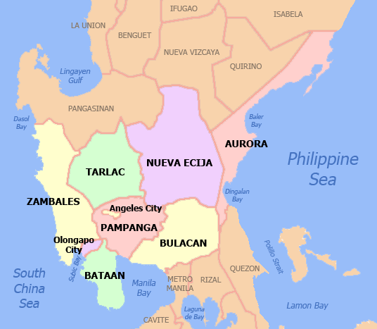
By Scorpion prinz at English Wikipedia, CC BY 2.5, https://commons.wikimedia.org/w/index.php?curid=2190379
Provinces of Region III: Central Luzon Region
Aurora:
Philippine Standard Geographical Code # 37700000
Aurora is a coastal province, and is composed of:
| Municipalities: | Barangay: |
|---|---|
| 8 | 151 |
| PSGC # | Town # | Creation Date: | Municipality: | Type: | Location: | Pop. (2020): | Pop. (2015): | Area (sq. km.): | Area (sq. mi.): | IDD: Area Code: | Zip Code: | Barangays: | Income Class: | District: |
|---|---|---|---|---|---|---|---|---|---|---|---|---|---|---|
| 37701000 | 1 | 8/19/1609 | Baler (Capitol) | Municipality | Coastal | 43,785 | 39,562 | 92.55 | 35.73 | 63 (0) 42 | 3200 | 13 | 4th Class | Lone District |
| 37702000 | 2 | 6/13/1609 | Casiguran | Municipality | Coastal | 26,564 | 24,313 | 715.43 | 276.23 | 63 (0) 42 | 3204 | 24 | 3rd Class | Lone District |
| 37703000 | 3 | 6/21/1959 | Dilasag | Municipality | Coastal | 17,102 | 15,835 | 306.25 | 118.24 | 63 (0) 42 | 3205 | 11 | 3rd Class | Lone District |
| 37704000 | 4 | 6/18/1966 | Dinalungan | Municipality | Coastal | 12,508 | 11,322 | 316.85 | 122.34 | 63 (0) 42 | 3206 | 9 | 5th Class | Lone District |
| 37705000 | 5 | 1962 | Dingalan | Municipality | Coastal | 27,878 | 25,482 | 304.55 | 117.59 | 63 (0) 42 | 3207 | 11 | 4th Class | Lone District |
| 37706000 | 6 | 1950 | Dipaculao | Municipality | Coastal | 33,131 | 29,736 | 361.64 | 139.63 | 63 (0) 42 | 3203 | 25 | 3rd Class | Lone District |
| 37707000 | 7 | 7/21/1949 | Maria Aurora | Municipality | Inland | 44,958 | 40,734 | 426.19 | 164.55 | 63 (0) 42 | 3202 | 40 | 2nd Class | Lone District |
| 37708000 | 8 | 1962 | San Luis | Municipality | Coastal | 29,824 | 27,352 | 623.86 | 240.87 | 63 (0) 42 | 3201 | 18 | 2nd Class | Lone District |
| Pop. (2020): | Pop. (2015): | Area (sq. km.): | Area (sq. mi.): | Barangays: | ||||||||||
| Totals: | 235,750 | 214,336 | 3,147 | 1,215.18 | 151 |
Bataan:
Philippine Standard Geographical Code # 30800000
Bataan is a coastal province and is composed of:
| Component City (1): | Municipalities: | Barangay: |
|---|---|---|
| Balanga City (Capitol) | 11 | 237 |
| PSGC # | Town # | Creation Date: | Municipality: | Type: | Location: | Pop. (2020): | Pop. (2015): | Area (sq. km.): | Area (sq. mi.): | IDD: Area Code: | Zip Code: | Barangays: | Income Class: | District: |
|---|---|---|---|---|---|---|---|---|---|---|---|---|---|---|
| 30801000 | 1 | 1587 | Abucay | Municipality | Coastal | 42,984 | 39,880 | 79.72 | 30.78 | 63 (0) 47 | 2114 | 25 | 1st Class | II |
| 30802000 | 2 | 1866 | Bagac | Municipality | Coastal | 31,365 | 26,936 | 231.20 | 89.27 | 63 (0) 47 | 2107 | 9 | 3rd Class | I |
| 30803000 | 3 | 1712 | Balanga City (Capitol) | Component City | Coastal | 104,173 | 96,061 | 111.63 | 43.10 | 63 (0) 47 | 2100 | 14 | 3rd Class | II |
| 30804000 | 4 | 1865 | Dinalupihan | Municipality | Inland | 118,209 | 106,371 | 92.52 | 35.72 | 63 (0) 47 | 2110 | 46 | 1st Class | I |
| 30805000 | 5 | 1852 | Hermosa | Municipality | Inland | 77,443 | 65,862 | 157.00 | 60.62 | 63 (0) 47 | 2111 | 23 | 1st Class | I |
| 30806000 | 6 | 10/4/1917 | Limay | Municipality | Coastal | 78,272 | 68,071 | 103.60 | 40.00 | 63 (0) 47 | 2104 | 12 | 1st Class | II |
| 30807000 | 7 | 1754 | Mariveles | Municipality | Coastal | 149,879 | 127,536 | 153.90 | 59.42 | 63 (0) 47 | 2105 | 18 | 1st Class | II |
| 30808000 | 8 | 1607 | Morong (Moron) | Municipality | Coastal | 35,394 | 29,901 | 219.20 | 84.63 | 63 (0) 47 | 2108 | 5 | 3rd Class | I |
| 30809000 | 9 | 1891 | Orani | Municipality | Coastal | 70,342 | 66,909 | 64.90 | 25.06 | 63 (0) 47 | 2108 | 29 | 1st Class | I |
| 30810000 | 10 | 1680 | Orion | Municipality | Coastal | 60,771 | 56,002 | 65.41 | 25.25 | 63 (0) 47 | 2112 | 23 | 2nd Class | II |
| 30811000 | 11 | 4/6/1917 | Pilar | Municipality | Coastal | 46,239 | 41,823 | 37.60 | 14.52 | 63 (0) 47 | 2102 | 19 | 3rd Class | II |
| 30812000 | 12 | 1699 | Samal | Municipality | Coastal | 38,302 | 35,298 | 56.30 | 21.74 | 63 (0) 47 | 2101 | 14 | 4th Class | I |
| Pop. (2020): | Pop. (2015): | Area (sq. km.): | Area (sq. mi.): | Barangays: | ||||||||||
| Totals: | 853,373 | 760,650 | 1,372.98 | 530.11 | 237 |
Bulacan:
Philippine Standard Geographical Code # 31400000
Bulacan is a coastal province connected to the Manila Bay and is composed of:
| Component City (4): | Municipalities: | Barangay: |
|---|---|---|
| Baliwag City | 28 | 569 |
| Malolos City (Capitol) | N/A | N/A |
| Meycauayan City | N/A | N/A |
| San Jose del Monte City | N/A | N/A |
| PSGC # | Town # | Creation Date: | Municipality: | Type: | Location: | Pop. (2020): | Pop. (2015): | Area (sq. km.): | Area (sq. mi.): | IDD: Area Code: | Zip Code: | Barangays: | Income Class: | District: |
|---|---|---|---|---|---|---|---|---|---|---|---|---|---|---|
| 31401000 | 1 | 1683 | Angat | Municipality | Inland | 65,617 | 59,237 | 74.00 | 29.00 | 63 (0) 44 | 3012 | 16 | 1st Class | III |
| 31402000 | 2 | 1596 | Balagtas (Bigaa) | Municipality | Inland | 77,018 | 73,929 | 28.66 | 11.07 | 63 (0) 44 | 3016 | 9 | 1st Class | II |
| 31403000 | 3 | 5/15/1734 | Baliwag City (Baliuag) | Component City | Inland | 168,470 | 149,954 | 45.05 | 17.39 | 63 (0) 44 | 3006 | 27 | 1st Class | II |
| 31404000 | 4 | 1582 | Bocaue | Municipality | Inland | 141,412 | 119,675 | 31.87 | 12.31 | 63 (0) 44 | 3018 | 19 | 1st Class | II |
| 31405000 | 5 | 1572 | Bulacan (Bulakan) | Municipality | Coastal-Manila Bay | 81,232 | 76,565 | 72.90 | 28.15 | 63 (0) 44 | 3017 | 14 | 1st Class | I |
| 31406000 | 6 | 4/26/1867 | Bustos | Municipality | Inland | 77,199 | 67,039 | 69.99 | 27.02 | 63 (0) 44 | 3007 | 14 | 2nd Class | II |
| 31407000 | 7 | 11/14/1571 | Calumpit | Municipality | Inland | 118,471 | 108,757 | 56.25 | 21.72 | 63 (0) 44 | 3003 | 29 | 1st Class | I |
| 31424000 | 24 | 9/13/1977 | Dona Remedios Trinidad | Municipality | Inland | 28,656 | 22,663 | 932.96 | 360.22 | 63 (0) 44 | 3009 | 8 | 1st Class | III |
| 31408000 | 8 | 1641 | Guiguinto | Municipality | Inland | 113,415 | 99,730 | 27.50 | 10.62 | 63 (0) 44 | 3015 | 14 | 1st Class | II |
| 31409000 | 9 | 4/22/1581 | Hagonoy | Municipality | Coastal-Manila Bay | 133,448 | 129,807 | 103.10 | 39.81 | 63 (0) 44 | 3002 | 26 | 1st Class | I |
| 31410000 | 10 | 11/14/1571 | Malolos City (Capitol) | Component City | Coastal-Manila Bay | 261,189 | 252,074 | 67.25 | 25.97 | 63 (0) 44 | 3000 | 51 | 1st Class | I |
| 31411000 | 11 | 1796 | Marilao | Municipality | Inland | 254,453 | 221,965 | 33.74 | 13.03 | 63 (0) 44 | 3019 | 16 | 1st Class | IV |
| 31412000 | 12 | 10/4/1578 | Meycauayan City | Component City | Inland | 225,673 | 209,083 | 32.10 | 12.39 | 63 (0) 44 | 3020 | 26 | 1st Class | IV |
| 31413000 | 13 | 1860 | Norzagaray | Municipality | Inland | 136,064 | 111,348 | 309.77 | 119.60 | 63 (0) 44 | 3013 | 13 | 1st Class | III |
| 31414000 | 14 | 1753 | Obando | Municipality | Coastal-Manila Bay | 59,978 | 59,197 | 52.10 | 20.12 | 63 (0) 44 | 3021 | 11 | 2nd Class | IV |
| 31415000 | 15 | 4/17/1946 | Pandi | Municipality | Inland | 155,115 | 89,075 | 31.20 | 12.05 | 63 (0) 44 | 3014 | 22 | 2nd Class | II |
| 31416000 | 16 | 1619 | Paobong | Municipality | Coastal-Manila Bay | 55,696 | 53,294 | 46.34 | 17.89 | 63 (0) 44 | 3001 | 14 | 3rd Class | I |
| 31417000 | 17 | 1602 | Plaridel | Municipality | Inland | 114,432 | 107,805 | 32.44 | 12.53 | 63 (0) 44 | 3004 | 19 | 1st Class | II |
| 31418000 | 18 | 1/20/1796 | Pulilan | Municipality | Inland | 108,836 | 97,323 | 39.89 | 15.40 | 63 (0) 44 | 3005 | 19 | 1st Class | I |
| 31419000 | 19 | 1885 | San Ildefonso | Municipality | Inland | 115,713 | 104,471 | 128.71 | 49.70 | 63 (0) 44 | 3010 | 36 | 1st Class | III |
| 31420000 | 20 | 3/2/1752 | San Jose del Monte City | Component City | Inland | 651,813 | 574,089 | 105.53 | 40.75 | 63 (0) 44 | 3023/3024 | 59 | 1st Class | Lone of San Jose |
| 31421000 | 21 | 9/29/1725 | San Miguel | Municipality | Inland | 172,073 | 153,882 | 231.40 | 89.34 | 63 (0) 44 | 3011 | 49 | 1st Class | III |
| 31422000 | 22 | 1758 | San Rafael | Municipality | Inland | 103,097 | 94,655 | 152.43 | 58.85 | 63 (0) 44 | 3008 | 34 | 1st Class | III |
| 31423000 | 23 | 1647 | Santa Maria | Municipality | Inland | 289,820 | 256,454 | 90.92 | 35.10 | 63 (0) 44 | 3022 | 24 | 1st Class | IV |
| Pop. (2020): | Pop. (2015): | Area (sq. km.): | Area (sq. mi.): | Barangays: | ||||||||||
| 3,708,890 | 3,292,071 | 2,796.10 | 1,080.03 | 569 |
Nueva Ecija:
Philippine Standard Geographical Code # 34900000
Nueva Ecija is a landlocked province and is composed of:
| Component City (5): | Municipalities: | Barangay (of which are Island Barangays): |
|---|---|---|
| Cabanatuan City | 27 | 855 |
| Gapan City | N/A | N/A |
| Science City of Munoz | N/A | N/A |
| Palayan City (Capitol) | N/A | N/A |
| San Jose City | N/A | N/A |
| PSGC # | Town # | Creation Date: | Municipality: | Type: | Location: | Pop. (2020): | Pop. (2015): | Area (sq. km.): | Area (sq. mi.): | IDD: Area Code: | Zip Code: | Barangays: | Income Class: | District: |
|---|---|---|---|---|---|---|---|---|---|---|---|---|---|---|
| 34901000 | 1 | Aliaga | Municipality | Landlocked | 70,363 | 63,543 | 90.04 | 34.76 | 63 (0) 44 | 3111 | 26 | 2nd Class | I | |
| 34902000 | 2 | 1760 | Bongabon | Municipality | Landlocked | 66,839 | 64,173 | 286.95 | 110.79 | 63 (0) 44 | 3128 | 28 | 2nd Class | III |
| 34903000 | 3 | 1750 | Cabanatuan City | Component City | Landlocked | 327,325 | 302,231 | 192.29 | 74.24 | 63 (0) 44 | 3100 | 89 | 1st Class | III |
| 34904000 | 4 | 1765 | Cabiao | Municipality | Landlocked | 85,862 | 79,007 | 111.83 | 43.18 | 63 (0) 44 | 3107 | 23 | 1st Class | IV |
| 34905000 | 5 | Carranglan | Municipality | Landlocked | 42,420 | 41,131 | 705.31 | 272.32 | 63 (0) 44 | 3123 | 17 | 2nd Class | II | |
| 34906000 | 6 | 1859 | Cuyapo | Municipality | Landlocked | 68,066 | 65,039 | 215.73 | 83.29 | 63 (0) 44 | 3117 | 52 | 1st Class | I |
| 34907000 | 7 | 6/15/1955 | Gabaldon (Bitulok & Sabani) | Municipality | Landlocked | 38,958 | 35,383 | 242.88 | 93.78 | 63 (0) 44 | 3131 | 16 | 4th Class | III |
| 34908000 | 8 | 1732 | Gapan City | Component City | Landlocked | 122,968 | 110,303 | 164.44 | 63.49 | 63 (0) 44 | 3105 | 25 | 4th Class | IV |
| 34909000 | 9 | 1957 | General Mamerto Nativadad | Municipality | Landlocked | 44,311 | 41,656 | 118.00 | 45.56 | 63 (0) 44 | 3125 | 20 | 4th Class | III |
| 34910000 | 10 | 1921 | General Tinio (Papaya) | Municipality | Landlocked | 55,925 | 47,865 | 533.08 | 205.82 | 63 (0) 44 | 3104 | 13 | 1st Class | IV |
| 34911000 | 11 | 1897 | Guimba | Municipality | Landlocked | 127,653 | 118,655 | 245.29 | 94.71 | 63 (0) 44 | 3115 | 64 | 1st Class | I |
| 34912000 | 12 | 6/18/1865 | Jaen | Municipality | Landlocked | 79,189 | 73,184 | 85.46 | 33.00 | 63 (0) 44 | 3109 | 27 | 1st Class | IV |
| 34913000 | 13 | 1/1/1917 | Laur | Municipality | Landlocked | 38,263 | 35,656 | 295.88 | 114.24 | 63 (0) 44 | 3129 | 17 | 3rd Class | III |
| 34914000 | 14 | 3/28/1894 | Licab | Municipality | Landlocked | 29,269 | 28,254 | 67.37 | 26.01 | 63 (0) 44 | 3112 | 11 | 4th Class | I |
| 34915000 | 15 | 5/11/1955 | Llanera | Municipality | Landlocked | 42,281 | 39,701 | 114.44 | 44.19 | 63 (0) 44 | 3126 | 22 | 4th Class | II |
| 34916000 | 16 | 1913 | Lupao | Municipality | Landlocked | 45,917 | 43,788 | 121.33 | 46.85 | 63 (0) 44 | 3122 | 24 | 4th Class | II |
| 34917000 | 17 | 1913 | Munoz; Science City of | Component City | Landlocked | 84,308 | 81,483 | 163.05 | 62.95 | 63 (0) 44 | 3119/3120 | 37 | 5th Class | II |
| 34918000 | 18 | 1880 | Nampicuan | Municipality | Landlocked | 14,471 | 14,954 | 52.60 | 20.31 | 63 (0) 44 | 3116 | 21 | 5th Class | I |
| 34919000 | 19 | 6/19/1965 | Palayan City (Capitol) | Component City | Landlocked | 45,383 | 41,041 | 101.40 | 39.15 | 63 (0) 44 | 3132 | 19 | 5th Class | III |
| 34920000 | 20 | 1701 | Pantabangan | Municipality | Landlocked | 31,763 | 29,925 | 392.56 | 151.57 | 63 (0) 44 | 3124 | 14 | 1st Class | II |
| 34921000 | 21 | Peñaranda | Municipality | Landlocked | 32,269 | 29,882 | 95.00 | 36.68 | 63 (0) 44 | 3103 | 10 | 4th Class | IV | |
| 34922000 | 22 | Quezon | Municipality | Landlocked | 41,845 | 40,592 | 68.53 | 26.46 | 63 (0) 44 | 3113 | 16 | 4th Class | I | |
| 34923000 | 23 | 1913 | Rizal | Municipality | Landlocked | 70,196 | 64,087 | 120.55 | 46.54 | 63 (0) 44 | 3127 | 27 | 3rd Class | II |
| 34924000 | 24 | San Antonio | Municipality | Landlocked | 83,060 | 77,836 | 153.56 | 59.29 | 63 (0) 44 | 3108 | 18 | 1st Class | IV | |
| 34925000 | 25 | San Isidro | Municipality | Landlocked | 54,372 | 51,612 | 56.49 | 21.81 | 63 (0) 44 | 3106 | 9 | 2nd Class | IV | |
| 34926000 | 26 | 3/19/1894 | San Jose City (Cabaritan) | Component City | Landlocked | 150,917 | 139,738 | 185.99 | 71.81 | 63 (0) 44 | 3121 | 38 | 2nd Class | II |
| 34927000 | 27 | San Leonardo | Municipality | Landlocked | 68,536 | 65,299 | 151.90 | 58.65 | 63 (0) 44 | 3102 | 15 | 1st Class | IV | |
| 34928000 | 28 | 8/1/1878 | Santa Rosa | Municipality | Landlocked | 75,649 | 69,467 | 147.15 | 56.81 | 63 (0) 44 | 3101 | 33 | 1st Class | III |
| 34929000 | 29 | Santo Domingo | Municipality | Landlocked | 61,092 | 57,943 | 74.88 | 28.91 | 63 (0) 44 | 3133 | 24 | 3rd Class | I | |
| 34930000 | 30 | 1872 | Talavera | Municipality | Landlocked | 132,338 | 124,829 | 140.92 | 54.41 | 63 (0) 44 | 3114 | 53 | 1st Class | I |
| 34931000 | 31 | Talugtug | Municipality | Landlocked | 25,236 | 23,817 | 93.95 | 36.27 | 63 (0) 44 | 3118 | 28 | 4th Class | I | |
| 34932000 | 32 | 1878 | Zaragoza | Municipality | Landlocked | 53,090 | 49,387 | 72.02 | 27.81 | 63 (0) 44 | 3110 | 19 | 3rd Class | I |
| Pop. (2020): | Pop. (2015): | Area (sq. km.): | Area (sq. mi.): | Barangays: | ||||||||||
| Totals: | 2,310,134 | 2,151,461 | 5,660.87 | 2,185.66 | 855 |
Pampanga:
Philippine Standard Geographical Code # 35400000
Pampanga is a coastal province connected to the Manila Bay.
It is the home of the independent city of Angeles City the former home of Clark Air Force Base (Now called Clark Airport).
It is composed of:
| Independent City (1): | Component City (2): | Municipalities: | Barangay: |
|---|---|---|---|
| Angeles City | Mabalacat City | 18 | 540 |
| N/A | San Fernando City (Capitol) | N/A | N/A |
| PSGC # | Town # | Creation Date: | Municipality: | Type: | Location: | Pop. (2020): | Pop. (2015): | Area (sq. km.): | Area (sq. mi.): | IDD: Area Code: | Zip Code: | Barangays: | Income Class: | District: |
|---|---|---|---|---|---|---|---|---|---|---|---|---|---|---|
| 35401000 | 1 | 1796 | Angeles City | Independent City | Landlocked | 462,928 | 411,634 | 60.27 | 23.27 | 63 (0) 45 | 2009 | 33 | 1st Class | I |
| 35402000 | 2 | Apalit | Municipality | Landlocked | 117,160 | 107,965 | 61.47 | 23.73 | 63 (0) 45 | 2016 | 12 | 1st Class | IV | |
| 35403000 | 3 | Arayat | Municipality | Landlocked | 144,875 | 133,492 | 134.48 | 51.92 | 63 (0) 45 | 2012 | 30 | 1st Class | III | |
| 35404000 | 4 | 1574 | Bacolor | Municipality | Landlocked | 48,066 | 39,460 | 71.70 | 27.68 | 63 (0) 45 | 2001 | 21 | 3rd Class | III |
| 35405000 | 5 | Candaba | Municipality | Landlocked | 119,497 | 111,586 | 176.40 | 68.11 | 63 (0) 45 | 2013 | 33 | 1st Class | IV | |
| 35406000 | 6 | 4/30/1867 | Floridablanca | Municipality | Landlocked | 135,542 | 125,163 | 175.48 | 67.75 | 63 (0) 45 | 2006 | 33 | 1st Class | II |
| 35407000 | 7 | 1561 | Guagua | Municipality | Landlocked | 128,893 | 117,430 | 48.67 | 18.79 | 63 (0) 45 | 2003 | 31 | 1st Class | II |
| 35408000 | 8 | Lubao | Municipality | Landlocked | 173,502 | 160,838 | 155.77 | 60.14 | 63 (0) 45 | 2005 | 44 | 1st Class | II | |
| 35409000 | 9 | 1712 | Mabalacat City | Component City | Landlocked | 293,244 | 250,799 | 83.18 | 32.12 | 63 (0) 45 | 2010 | 27 | 1st Class | I |
| 35410000 | 10 | Macabebe | Municipality | Landlocked | 78,151 | 75,850 | 105.16 | 40.60 | 63 (0) 45 | 2018 | 25 | 1st Class | IV | |
| 35411000 | 11 | 4/30/1605 | Magalang | Municipality | Landlocked | 124,188 | 113,147 | 97.32 | 37.58 | 63 (0) 45 | 2011 | 27 | 1st Class | I |
| 35412000 | 12 | 1907 | Masantol | Municipality | Landlocked | 57,990 | 57,063 | 48.25 | 18.63 | 63 (0) 45 | 2017 | 26 | 2nd Class | IV |
| 35413000 | 13 | 4/24/1581 | Mexico | Municipality | Landlocked | 173,403 | 154,624 | 117.41 | 45.33 | 63 (0) 45 | 2021 | 43 | 1st Class | III |
| 35414000 | 14 | 8/27/1614 | Minalin | Municipality | Landlocked | 48,380 | 47,713 | 48.27 | 18.64 | 63 (0) 45 | 2019 | 15 | 4th Class | IV |
| 35415000 | 15 | 10/31/1594 | Porac | Municipality | Landlocked | 140,751 | 124,381 | 314.00 | 121.24 | 63 (0) 45 | 2008 | 29 | 1st Class | II |
| 35416000 | 16 | 8/16/1754 | San Fernando City (Capitol) | Component City | Landlocked | 354,666 | 306,659 | 67.74 | 26.15 | 63 (0) 45 | 2000 | 36 | 1st Class | III |
| 35417000 | 17 | 1761 | San Luis | Municipality | Landlocked | 58,551 | 54,106 | 56.83 | 21.94 | 63 (0) 45 | 2014 | 17 | 3rd Class | IV |
| 35418000 | 18 | 11/15/1771 | San Simon | Municipality | Landlocked | 59,182 | 53,198 | 57.37 | 22.15 | 63 (0) 45 | 2015 | 14 | 3rd Class | IV |
| 35419000 | 19 | Santa Ana | Municipality | Landlocked | 61,537 | 55,178 | 39.84 | 15.38 | 63 (0) 45 | 2022 | 14 | 3rd Class | III | |
| 35420000 | 20 | Santa Rita | Municipality | Landlocked | 48,209 | 40,979 | 29.76 | 11.49 | 63 (0) 45 | 2002 | 10 | 4th Class | II | |
| 35421000 | 21 | 9/15/1792 | Santo Tomas | Municipality | Landlocked | 42,846 | 40,475 | 21.30 | 8.22 | 63 (0) 45 | 2020 | 8 | 4th Class | IV |
| 35422000 | 22 | Sasmuan | Municipality | Landlocked | 29,076 | 28,004 | 91.80 | 35.44 | 63 (0) 45 | 2004 | 12 | 4th Class | II | |
| Pop. (2020): | Pop. (2015): | Area (sq. km.): | Area (sq. mi.): | Barangays: | ||||||||||
| Totals: | 2,900,637 | 2,609,744 | 2,062.47 | 796.30 | 540 |
Tarlac:
Philippine Standard Geographical Code # 36900000
Tarlac is a landlocked province and is composed of:
| Component City (1): | Municipalities: | Barangay: |
|---|---|---|
| Tarlac City (Capitol) | 18 | 511 |
| PSGC # | Town # | Creation Date: | Municipality: | Type: | Location: | Pop. (2020): | Pop. (2015): | Area (sq. km.): | Area (sq. mi.): | IDD: Area Code: | Zip Code: | Barangays: | Income Class: | District: |
|---|---|---|---|---|---|---|---|---|---|---|---|---|---|---|
| 36901000 | 1 | 1870 | Anao | Municipality | Landlocked | 12,208 | 11,528 | 23.87 | 9.22 | 63 (0) 45 | 2310 | 18 | 1st Class | I |
| 36902000 | 2 | 6/6/1710 | Bamban | Municipality | Landlocked | 78,260 | 69,466 | 251.98 | 97.29 | 63 (0) 45 | 2317 | 15 | 2nd Class | III |
| 36903000 | 3 | 1838 | Camiling | Municipality | Landlocked | 87,319 | 83,248 | 140.53 | 54.26 | 63 (0) 45 | 2306 | 61 | 1st Class | II |
| 36904000 | 4 | 9/10/1710 | Capas | Municipality | Landlocked | 156,056 | 140,202 | 376.39 | 145.32 | 63 (0) 45 | 2315 | 20 | 1st Class | III |
| 36905000 | 5 | 1863 | Concepcion | Municipality | Landlocked | 169,953 | 154,188 | 242.99 | 93.82 | 63 (0) 45 | 2316 | 45 | 1st Class | III |
| 36906000 | 6 | Gerona | Municipality | Landlocked | 94,485 | 87,531 | 128.89 | 49.76 | 63 (0) 45 | 2302 | 44 | 1st Class | II | |
| 36907000 | 7 | 1/24/1892 | La Paz | Municipality | Landlocked | 68,952 | 64,017 | 114.33 | 44.14 | 63 (0) 45 | 2314 | 21 | 2nd Class | III |
| 36908000 | 8 | 1917 | Mayantoc | Municipality | Landlocked | 32,597 | 32,232 | 311.42 | 120.24 | 63 (0) 45 | 2304 | 24 | 3rd Class | I |
| 36909000 | 9 | 1887 | Moncada | Municipality | Landlocked | 62,819 | 57,787 | 85.75 | 33.11 | 63 (0) 45 | 2308 | 37 | 1st Class | I |
| 36910000 | 10 | 1712 | Paniqui | Municipality | Landlocked | 103,003 | 92,606 | 105.16 | 40.60 | 63 (0) 45 | 2307 | 35 | 1st Class | I |
| 36911000 | 11 | Pura | Municipality | Landlocked | 25,781 | 23,712 | 31.01 | 11.97 | 63 (0) 45 | 2312 | 16 | 4th Class | I | |
| 36912000 | 12 | 1/1/1921 | Ramos (Bani) | Municipality | Landlocked | 22,879 | 21,350 | 24.40 | 9.42 | 63 (0) 45 | 2311 | 9 | 5th Class | I |
| 36913000 | 13 | San Clemente | Municipality | Landlocked | 13,181 | 12,657 | 49.73 | 19.20 | 63 (0) 45 | 2305 | 12 | 5th Class | I | |
| 36914000 | 18 | 1990 | San Jose | Municipality | Landlocked | 41,182 | 36,253 | 592.81 | 228.89 | 63 (0) 45 | 2318 | 13 | 3rd Class | II |
| 36915000 | 14 | 2/25/1909 | San Manuel | Municipality | Landlocked | 28,387 | 25,504 | 42.10 | 16.25 | 63 (0) 45 | 2309 | 15 | 4th Class | I |
| 36916000 | 15 | Santa Ignacia | Municipality | Landlocked | 51,626 | 47,538 | 146.07 | 56.40 | 63 (0) 45 | 2303 | 24 | 2nd Class | I | |
| 36917000 | 16 | 1788 | Tarlac City (Capitol) | Component City | Landlocked | 385,398 | 342,493 | 274.66 | 106.05 | 63 (0) 45 | 2300 | 76 | 1st Class | II |
| 36918000 | 17 | 3/28/1855 | Victoria | Municipality | Landlocked | 69,370 | 63,715 | 111.51 | 43.05 | 63 (0) 45 | 2313 | 26 | 2nd Class | II |
| Pop. (2020): | Pop. (2015): | Area (sq. km.): | Area (sq. mi.): | Barangays: | ||||||||||
| Totals: | 1,503,456 | 1,366,027 | 3,053.60 | 1,178.99 | 511 |
Zambales:
Philippine Standard Geographical Code # 37100000
Zambales is a coastal province and is composed of:
| Independent City (1): | Municipalities: | Barangay (of which are Island Barangays): |
|---|---|---|
| Olongapo City | 13 | 248 (4) |
| PSGC # | Town # | Creation Date: | Municipality: | Type: | Location: | Pop. (2020): | Pop. (2015): | Area (sq. km.): | Area (sq. mi.): | IDD: Area Code: | Zip Code: | Barangays: | Island Bry: | Income Class: | District: |
|---|---|---|---|---|---|---|---|---|---|---|---|---|---|---|---|
| 37101000 | 1 | 1572 | Botolan | Municipality | Inland | 66,739 | 57,707 | 735.28 | 283.89 | 63 (0) 47 | 2202 | 31 | 0 | 1st Class | II |
| 37102000 | 2 | 1908 | Cabangan | Municipality | Coastal | 28,118 | 25,163 | 175.29 | 67.68 | 63 (0) 47 | 2203 | 22 | 0 | 4th Class | II |
| 37103000 | 3 | 1870 | Candelaria | Municipality | Coastal | 30,263 | 27,174 | 333.59 | 128.80 | 63 (0) 47 | 2212 | 16 | 0 | 3rd Class | II |
| 37104000 | 4 | 1743 | Castillejos | Municipality | Inland | 67,889 | 64,841 | 92.99 | 35.90 | 63 (0) 47 | 2208 | 14 | 0 | 1st Class | I |
| 37105000 | 5 | 1611 | Iba (Capitol) | Municipality | Coastal | 55,581 | 50,506 | 153.38 | 59.22 | 63 (0) 47 | 2201 | 14 | 0 | 1st Class | II |
| 37106000 | 6 | 1910 | Masinloc | Municipality | Coastal + Island | 54,529 | 47,719 | 331.50 | 127.99 | 63 (0) 47 | 2211 | 13 | 1 | 1st Class | II |
| 37108000 | 8 | 11/4/1750 | Olongapo City | Independent City | Coastal | 260,317 | 233,040 | 185.00 | 71.43 | 63 (0) 47 | 2200 | 17 | 0 | 1st Class | I |
| 37107000 | 7 | 1870 | Palauig | Municipality | Coastal + Island | 39,784 | 34,947 | 310.00 | 119.69 | 63 (0) 47 | 2210 | 19 | 1 | 3rd Class | II |
| 37109000 | 9 | 1849 | San Antonio | Municipality | Coastal | 37,450 | 34,661 | 188.12 | 72.63 | 63 (0) 47 | 2206 | 14 | 0 | 2nd Class | II |
| 37110000 | 10 | 1795 | San Felipe | Municipality | Coastal | 25,033 | 23,183 | 111.60 | 43.09 | 63 (0) 47 | 2204 | 11 | 0 | 4th Class | II |
| 37111000 | 11 | 1843 | San Marcelino | Municipality | Inland | 37,719 | 33,665 | 416.86 | 160.95 | 63 (0) 47 | 2207 | 18 | 0 | 1st Class | I |
| 37112000 | 12 | 2/12/1846 | San Narciso | Municipality | Coastal | 30,759 | 28,360 | 71.60 | 27.64 | 63 (0) 47 | 2205 | 17 | 0 | 4th Class | I |
| 37113000 | 13 | 1612 | Santa Cruz | Municipality | Coastal + Islands | 63,839 | 58,151 | 438.46 | 169.29 | 63 (0) 47 | 2213 | 26 | 2 | 1st Class | II |
| 37114000 | 14 | 1572 | Subic | Municipality | Coastal | 111,912 | 104,771 | 287.16 | 110.87 | 63 (0) 47 | 2209 | 16 | 0 | 1st Class | II |
| Pop. (2020): | Pop. (2015): | Area (sq. km.): | Area (sq. mi.): | Barangays: | Island Bry: | ||||||||||
| Totals: | 909,932 | 823,888 | 3,830.83 | 1,479.07 | 248 | 4 |