Luzon Island Group:
Luzon Island Group: An Overview
The Luzon Island Group is one of the three major island groups in the Philippines, alongside the Visayas and Mindanao. It is the largest and most populous island group in the country and serves as a key political, economic, and cultural hub.
Geography
The Luzon Island Group is located in the northern part of the Philippines. It includes:
- Luzon Island (the largest island in the country)
- Nearby islands such as Mindoro, Marinduque, Masbate, Catanduanes, Romblon, and several smaller islands.
Luzon is bordered by the South China Sea to the west, the Philippine Sea to the east, and the Luzon Strait to the north, which separates it from Taiwan.
Regions Included
The Luzon Island Group is made up of the following administrative regions:
- Ilocos Region (Region I)
- Cagayan Valley (Region II)
- Central Luzon (Region III)
- CALABARZON (Region IV-A)
- MIMAROPA (Region IV-B)
- Bicol Region (Region V)
- Cordillera Administrative Region (CAR)
- National Capital Region (NCR)
Each region contributes to the rich diversity in culture, language, and economy found within the island group.
Population and Economy
- Luzon Island Group houses Metro Manila, the capital region, which includes Quezon City, Manila, Makati, and other major cities.
- It is the most populous of the three island groups, with more than half of the country’s population residing here.
- The group is the economic center of the Philippines, with industries ranging from agriculture and manufacturing to finance and technology.
Culture and Languages
- The cultural landscape of Luzon is varied, with influences from Indigenous traditions, Spanish colonization, American occupation, and modern globalization.
- Major languages include Tagalog, Ilocano, Bicolano, Kapampangan, Pangasinense, and many others.
- Luzon is also home to various indigenous groups such as the Ifugao, Kalinga, and Aeta, each with distinct cultures and traditions.
Key Landmarks and Attractions
- Mayon Volcano (Albay) – Famous for its perfect cone shape.
- Banaue Rice Terraces (Ifugao) – A UNESCO World Heritage Site.
- Taal Volcano (Batangas) – One of the most active volcanoes in the Philippines.
- Intramuros (Manila) – The historic Spanish-era walled city.
- Baguio City – The summer capital of the Philippines due to its cool climate.
Significance
The Luzon Island Group plays a crucial role in the identity and functionality of the Philippines. It combines rich history, vibrant culture, and strong economic influence, making it a cornerstone of national development and heritage.
| PSGC # Base: | Region # | Region Name: | Regional Center: | Pop. (2020): | Area (sq. km.): | Area (sq. mi.): | Provinces: | Ind. Cities: | Comp. Cities: | Municipalities: | Barangays: | # Island Brys: |
|---|---|---|---|---|---|---|---|---|---|---|---|---|
| 14 | 14 | CAR- Cordillera Administrative Region | Baguio City, Benguet | 1,797,660 | 19,422.03 | 7,498.88 | 6 | 0 | 2 | 75 | 1,176 | 0 |
| 1 | 1 | Ilocos Region | San Fernando, La Union | 5,301,139 | 13,012.60 | 5,042.20 | 4 | 1 | 8 | 116 | 3,265 | 26 |
| 2 | 2 | Cagayan Valley Region | Tuguegarao City, Cagayan | 3,685,744 | 28,228.83 | 10,899.21 | 5 | 0 | 3 | 89 | 2,311 | 43 |
| 3 | 3 | Central Luzon Region | San Fernando, Pampanga | 12,422,172 | 22,014.63 | 8,499.89 | 7 | 2 | 12 | 116 | 3,102 | 9 |
| 4 | 4-a | CALABARZON Region (Southern Tagalog Mainland) | Calamaba, Laguna | 16,195,042 | 16,873.31 | 6,514.82 | 5 | 1 | 18 | 123 | 4,018 | 170 |
| 17 | 4-b | MIMAROPA Region (Southwestern Tagalog) | Calapan, Oriental Mindoro | 3,228,558 | 29,620.90 | 11,436.70 | 5 | 0 | 2 | 71 | 1,458 | 628 |
| 5 | 5 | Bicol Region (Bicol) | Legazpi City, Albay | 6,082,165 | 18,155.82 | 7,010.00 | 6 | 1 | 6 | 108 | 3,498 | 1,229 |
| 13 | N/A | Nation Capitol Region (NCR) | Manila, NCR | 13,497,565 | 334.70 | 156.63 | 0 | 1 | 15 | 1 | 1,705 | 0 |
| Pop. (2020): | Area (sq. km.): | Area (sq. mi.): | Provinces: | Ind. Cities: | Comp. Cities: | Municipalities: | Barangays: | # Island Brys: | ||||
| Totals: | 62,210,045 | 130,789.51 | 50,048.33 | 38 | 6 | 66 | 699 | 20,533 | 2,105 |
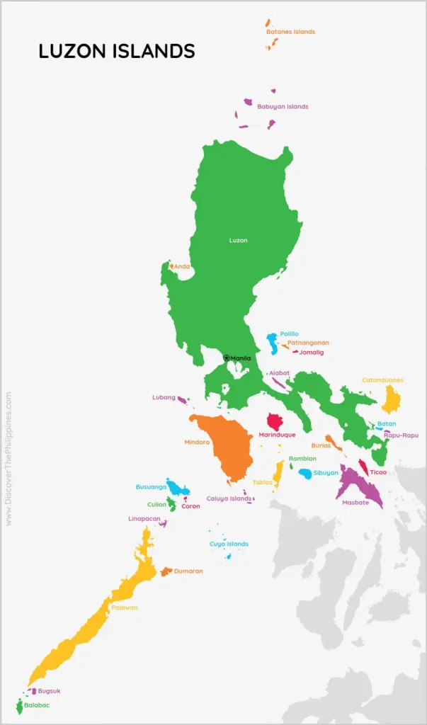
map from www.discoverthephilippines.com